Login

Zabudli ste prihlasovacia meno

Cookies have to be accepted!
Your browser's cookie functionality is disabled. Please enable this functionality.

Not a member yet?

Register now
Login

Available for registred users only

Log in to use this feature.

Zabudli ste prihlasovacia meno

Cookies have to be accepted!
Your browser's cookie functionality is disabled. Please enable this functionality.

Not a member yet?

Register now
Filter
Kategórie
Advanced filters
  • Dĺžka (km)
  • výškomer
Uložiť filter Reset filter

TrackRank

QRCode

Technical data

Dĺžka21,7 km výškomer533 m Way down511 m Doba03:00 h:m dátum06.10.2011
ohodnotenia Author Kraj pôžitok z túry kondícia technika

štatistika

1900 náhľady ohodnotenia 55 Stiahnutia priemer
Rate
  • list trasy
  • príjazd
  • Stiahnutia

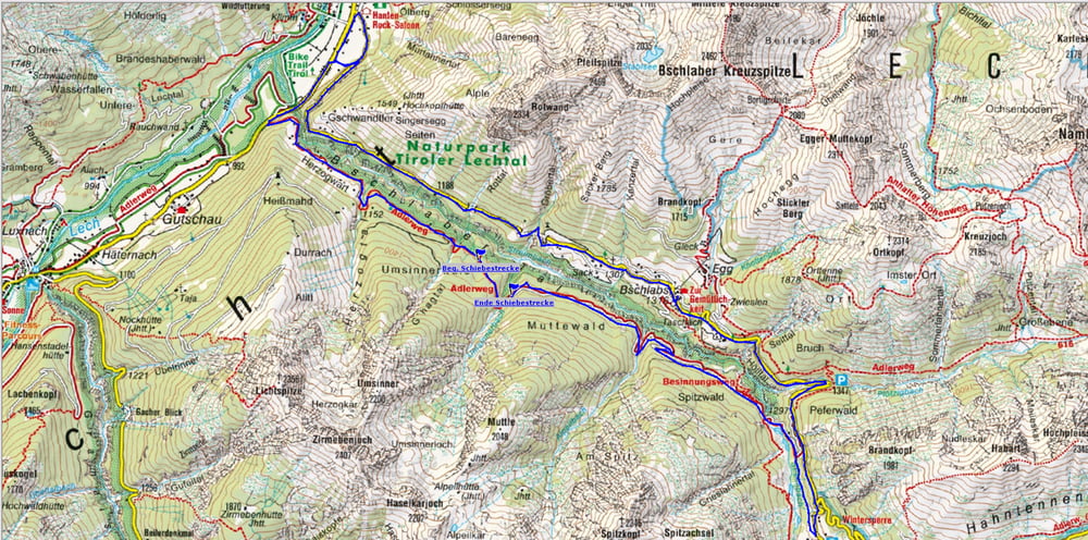
klein, aber fein. Landschaftlich schöne Tour durch das Bschlabertal auf einem Teil des Adlerweges  von Elmen bis Boden mit einer Schiebestrecke von 900 mtr. Zurück gehts flott bergab auf der L 266 zum Ausgangspunkt.

Hatte leider keinen Fotoapparat dabei.

Mapa trasy a výškový profil

  • Open Street Map
  • Google
Minimum height 973 m Maximum height 1405 m Detailný pohľad

More about the tour author

yr1willi
Member since 2006

Send private message

komentáre

Parkmöglichkeit am südl. Ende von Elmen

GPS trasy

Trackpoints
  • GPX / Garmin Map Source (gpx) download
  • TCX / Garmin Training Center® (tcx) download
  • CRS / Garmin Training Center® (crs) download
  • Google Earth (kml) download
  • G7ToWin (g7t) download
  • TTQV (trk) download
  • Overlay (ovl) download
  • Fugawi (txt) download
  • Kompass (DAV) Track (tk) download
  • list trasy (pdf) download
  • Original file of the author (gpx) download

More about the tour author

yr1willi
Member since 2006

Send private message
Share track
Add to my favorites
Remove from my favorites
Edit tags
My score
Rate
trasa: Bschlabertal
Druh: horský bicykel
Dĺžka: 21,7 km
Evaluated on:
Doba:
Day(s)
Hour(s)
Minute(s)
ohodnotenie: Kraj pôžitok z túry kondícia technika