Login

Zabudli ste prihlasovacia meno

Cookies have to be accepted!
Your browser's cookie functionality is disabled. Please enable this functionality.

Not a member yet?

Register now
Login

Available for registred users only

Log in to use this feature.

Zabudli ste prihlasovacia meno

Cookies have to be accepted!
Your browser's cookie functionality is disabled. Please enable this functionality.

Not a member yet?

Register now
Filter
Kategórie
Advanced filters
  • Dĺžka (km)
  • výškomer
Uložiť filter Reset filter

TrackRank

QRCode

Technical data

Dĺžka88,7 km výškomer2003 m Way down2005 m Doba1 day 7 h dátum18.01.2012
ohodnotenia Author Kraj pôžitok z túry kondícia technika

štatistika

337 náhľady ohodnotenia 35 Stiahnutia priemer
Rate
  • list trasy
  • príjazd
  • Stiahnutia
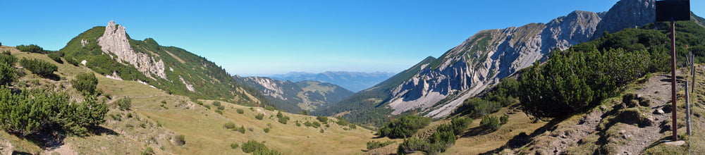
Dem Rheindamm entlang bis Schaan, Am Schloß vorbei nach Gaflei, den Weg zur Silumstr. ist, denke ich, am WE nichts fürs MTB, hinab nach Steg, rund um den Schönberg, Schiebestrecke ca. 30 Min., dann zum Matlerjoch (Grenzübertritt) und hinaus auf die Gampalpe, Latz, Gampelün, Frastanz, Feldkirch

galéria trás

Mapa trasy a výškový profil

  • Open Street Map
  • Google
Minimum height 422 m Maximum height 1856 m Detailný pohľad

More about the tour author

kumma14
Member since 2012

Send private message

komentáre

GPS trasy

Trackpoints
  • GPX / Garmin Map Source (gpx) download
  • TCX / Garmin Training Center® (tcx) download
  • CRS / Garmin Training Center® (crs) download
  • Google Earth (kml) download
  • G7ToWin (g7t) download
  • TTQV (trk) download
  • Overlay (ovl) download
  • Fugawi (txt) download
  • Kompass (DAV) Track (tk) download
  • list trasy (pdf) download
  • Original file of the author (gpx) download

More about the tour author

kumma14
Member since 2012

Send private message
Share track
Add to my favorites
Remove from my favorites
Edit tags
My score
Rate
trasa: Matlerjoch
Druh: horský bicykel
Dĺžka: 88,7 km
Evaluated on:
Doba:
Day(s)
Hour(s)
Minute(s)
ohodnotenie: Kraj pôžitok z túry kondícia technika