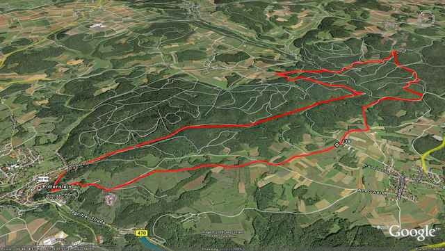
Trail head is in the town of Pottenstein in parking lot across from Norma grocery store. Starts on a residential road and then shortly crosses a bridge up another short residential road onto fine single track that follows a small stream (keep stream on your left). Excellent views of various cliffs and rock formations and small meadows along the river (Puttlach). Eventually single track ends and you have to cross the stream again on a small foot bridge. Continue with the stream on your right (turns back into some nice single track) and follow MTB trail signs. About 2.4 miles into the ride the route takes a left steep uphill climb to some open fields and then wanders back right around to some short and steep technical single track down hill back to the stream. Cross the small wood bridge and follow trail signs back up another steep hill and eventually into some more fields and onto asphalt and the edge of a small town, Hollensberg (a 1400 year old castle ruin rests atop the hill in this town and offers some wide views). Here in a small parking lot, the trail turns sharp right through some tight rock formations and heads on to some mixed up and downhill double and single track for a distance leading to a deer stand where the trail sign leads you down a long and steep downhill single track (rough with roots and slippery when wet). At the bottom of the hill follow the fire road to the right. For variety, I took the trial with a red dot to the left to the top to the ridge. The actual MTB trail continues a bit past this detour but leads you to the same place, open fields on top of a ridge line with some good views. Follow the ridge in open country to a point where the dirt road splits right to a grass trail (look for the park benchs) and follow this fun section to the top of a hilltop view point (tall red and white pole here) and a grand scene of Pottenstein and the castle. A secret view point is the mountain hut to the North about 50 meters before the grand view point (with the red and white pole), if you find it be real careful - serious cliffs abound! From here travers back down to the road, past the castle and back into Pottenstein. FUN ride with some hard and long climbs inter mixed.
Galería de rutas
Mapa de la ruta y perfil de altitud
Minimum height 311 m
Maximum height 506 m
Comentarios
In the Town of Pottenstein
Tracks GPS
Puntos del track-
GPX / Garmin Map Source (gpx) download
-
TCX / Garmin Training Center® (tcx) download
-
CRS / Garmin Training Center® (crs) download
-
Google Earth (kml) download
-
G7ToWin (g7t) download
-
TTQV (trk) download
-
Overlay (ovl) download
-
Fugawi (txt) download
-
Kompass (DAV) Track (tk) download
-
Hoja de ruta (pdf) download
-
Original file of the author (gpx) download
Añadir a mis favoritos
Eliminar de mis favoritos
Edit tags
Open track
Mi valoración
Rate


Tour gefahren
Ich bin heute deine Tour gefahren. Ich bin allerdings ein Enduro-Fahrer und daher war das erste Stück für mich nicht so toll, da es nur breite Schotterpisten waren. Allerdings wurde die Tour ab der Hälfte richtig toll. Besonders das Stück an der Püttlach entlang ist super.
Im gannzen Würde ich der Tour 3,5 von 5 möglichen Sternen geben.
Danke trotzdem für die Mühe
Tour am 31.07.2011
Tolle Tour, die sich in jedem Fall lohnt !