


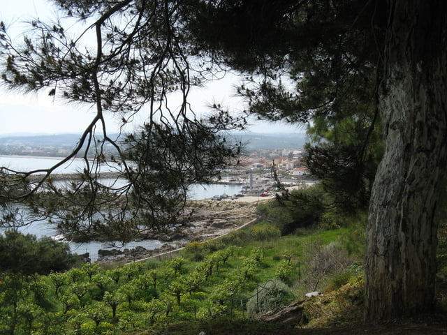
The walk starts in the center of Kolimbari. From the bus stop follow the signs Moni Gonia and Afrata. First you pass the nice fishing harbour. The monastery of Moni Gonia is only about 1 km North from Kolimbari. It is open for visitors in the morning, After the monastery continue the asphalt road along the coast. After a while the road starts to climb inwards to the small village of Afrata. There you’ll find two small tavernas and one supermarket for refreshing after the moderate climb.Turn left and pass the church. Now you will climb slowly in open landscape to the next village Astratigos. About 200 meters after the village turn left on a gravel path. Kolimbaria area is well-known of high-quality olive oil. On both sides the slopes are covered with olive trees. At a T-junction turn left in the direction of the see. You are slowly descending on a concrete track to Grimbiliana where you meet with a asphalt road leading back to Kolimbari.
Galería de rutas


Mapa de la ruta y perfil de altitud
Minimum height -30 m
Maximum height 190 m
More about the tour author

|
Anatonius |
Comentarios

RolandTaufkirchen
al 06.08.2009
schade, dass keine Beschreibung dabei ist!
Freqent bus connections from Hania to Kolimbari and Kastelli. Bus stop is in the centr of Kolimbari.
Tracks GPS
Puntos del track-
GPX / Garmin Map Source (gpx) download
-
TCX / Garmin Training Center® (tcx) download
-
CRS / Garmin Training Center® (crs) download
-
Google Earth (kml) download
-
G7ToWin (g7t) download
-
TTQV (trk) download
-
Overlay (ovl) download
-
Fugawi (txt) download
-
Kompass (DAV) Track (tk) download
-
Hoja de ruta (pdf) download
-
Original file of the author (gpx) download
More about the tour author
|
|
Anatonius |
Añadir a mis favoritos
Eliminar de mis favoritos
Edit tags
Open track
Mi valoración
Rate