

Start und Ziel: Lauf an der Pegnitz, Parkplatz an der Bitterbachhalle -
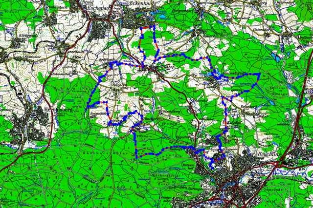
Kleine Tour durchs Neunhofer Land mit zahlreichen Auf und Ab.
Nördlich von Lauf fahren wir ein Stück durch den Nürnberger Spitalwald hinauf nach Günthersbühl, über Ödenberg und Beerbach vorbei an Neunhof nach Eckenhaid. Weiter geht es über Flur- und Waldwege durch Simonshofen zurück nach Lauf.
Kleine Tour durchs Neunhofer Land mit zahlreichen Auf und Ab.
Nördlich von Lauf fahren wir ein Stück durch den Nürnberger Spitalwald hinauf nach Günthersbühl, über Ödenberg und Beerbach vorbei an Neunhof nach Eckenhaid. Weiter geht es über Flur- und Waldwege durch Simonshofen zurück nach Lauf.
Galerie du tour
Carte du tour et altitude
Minimum height 330 m
Maximum height 423 m
More about the tour author

|
erwin.janko |
Commentaires

B14 Nürnberg – Lauf an der Pegnitz, in Lauf Richtung Neunhof, Eschenau
A 9 Ausfahrt Lauf Süd
Bahnhof Lauf rechts der Pegnitz
A 9 Ausfahrt Lauf Süd
Bahnhof Lauf rechts der Pegnitz
Tracks GPS
Trackpoints-
GPX / Garmin Map Source (gpx) download
-
TCX / Garmin Training Center® (tcx) download
-
CRS / Garmin Training Center® (crs) download
-
Google Earth (kml) download
-
G7ToWin (g7t) download
-
TTQV (trk) download
-
Overlay (ovl) download
-
Fugawi (txt) download
-
Kompass (DAV) Track (tk) download
-
Feuille de tours (pdf) download
-
Original file of the author (g7t) download
More about the tour author
|
|
erwin.janko |
Add to my favorites
Remove from my favorites
Edit tags
Open track
My score
Rate