Login

Login oublié ?

Cookies have to be accepted!
Your browser's cookie functionality is disabled. Please enable this functionality.

Not a member yet?

Register now
Login

Available for registred users only

Log in to use this feature.

Login oublié ?

Cookies have to be accepted!
Your browser's cookie functionality is disabled. Please enable this functionality.

Not a member yet?

Register now
Filter
Catégories
Advanced filters
  • Longueur (km)
  • Altimètre
Enregistrer le filtre Reset filter

TrackRank

QRCode

Technical data

Longueur27,9 km Altimètre0 m Way down0 m Durée01:00 h:m Date26.01.2005
Evaluations Author User Paysage Aspect amusement Condition Technique

Statistiques

4703 Vues 1 Evaluation 456 Téléchargements 4.00 Moyenne
Rate
  • Feuille de tours
  • Arrivée
  • Téléchargements

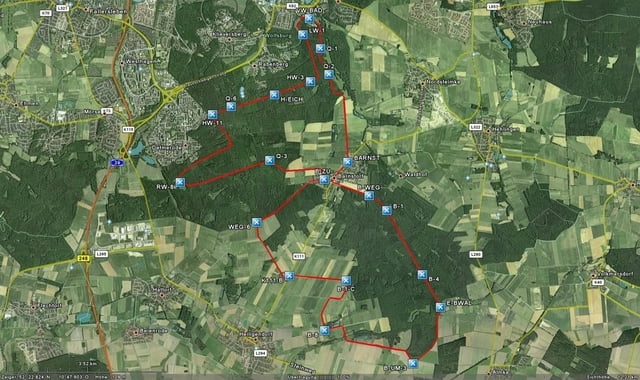
Meine Strecke

Start und Ziel:

Parkplatz am VW-Bad in Wolfsburg,
wir fahren links am
VW-Bad im Stadtwald lang.
Nachdem wir ein paar Minuten
auf dem Hauptweg gefahren sind,
liegt links eine kleine Erfrischung
„Brunnen zum Kaiserstuhl“
damit können wir unsere Wasserflaschen
auffüllen – schmeckt lecker.
Wir haben von den Brunnen und Quellen
noch mehr bei uns im Wald.
Also verdursten wird man nicht,
weiter geht’s Richtung Barnstorf,
durch den Barnstorfer Wald wo wir wieder
nachher zurückkommen
und in Richtung VW-Bad
wieder ans Ziel kommen.


weitere Touren hier in Wolfsburg und Umgebung

liegen auf meiner Homepage

www.wolfsburg-gps-tour.de

viel Spaß beim nachfahren

Further information at

http://www.wolfsburg-gps-tour.de

Galerie du tour

Carte du tour et altitude

  • Open Street Map
  • Google
Minimum height 99999 m Maximum height 2147483647 m Vue de détail

More about the tour author

KlausWob
Member since 2004

Send private message

Commentaires

gegenüber vom Großen Schiller Teich
Berliner Ring beim Porsche Stadion
Parkplatz am VW-Bad

Tracks GPS

Trackpoints
  • GPX / Garmin Map Source (gpx) download
  • TCX / Garmin Training Center® (tcx) download
  • CRS / Garmin Training Center® (crs) download
  • Google Earth (kml) download
  • G7ToWin (g7t) download
  • TTQV (trk) download
  • Overlay (ovl) download
  • Fugawi (txt) download
  • Kompass (DAV) Track (tk) download
  • Feuille de tours (pdf) download
  • Original file of the author (g7t) download

More about the tour author

KlausWob
Member since 2004

Send private message
Share track
Add to my favorites
Remove from my favorites
Edit tags
My score
Rate
Tour: Meine Strecke
Cat.: Mountainbike
Longueur: 27,9 km
Evaluated on:
Durée:
Day(s)
Hour(s)
Minute(s)
Evaluation: Paysage Aspect amusement Condition Technique