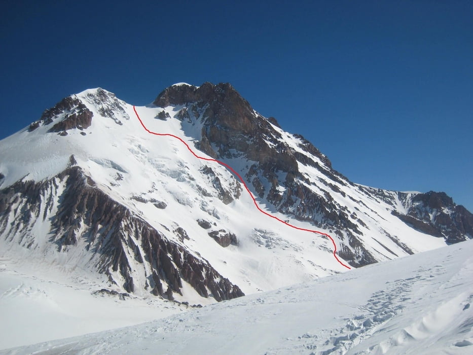
Mein eigentliches Zile war die SO-Rinne, aber da dort ein frischer Schneebrettabriss und noch weitere eingewehte Stellen sowie viel Blankeis waren, war mir die Sache zu heikel. Stattdessen habe ich mir eine schöne Linie durch die Südwand herausgesucht. Rundtrip ab Sameba-Kirche in einem Tag. Datum: 2. Mai 2013
Aufsteig über den Normlaweg (siehe Beschreibung Kazbeg), 3h bis zur Bethlemi-Hütte, weitere 4, am Ende ziemlich zäh, zum Gipfel. Abfahrt vom Sattel gegen 11:30 zuerst rechtshaltend (hier firnt es am schnellsten auf), dann immer links haltend bei geschätzten 35° Durchschnittsneigung die fantastische leicht aufgefirnte Flanke hinab. Unten schmaler Durschlupf zwischen gletscherbruch und Fels. alternativ kann links (evtl. über Geröll) hinausgequert werden, oder halb rechts zwischen den zwei Gletscherbrüchen hindurch zur Aufstiegsroute in der Nähe des weißen Kreuzes hinabgefahren werden. Die weitere Abfahrt wie Aufstieg, nur unten rechts haltend entlang dem Bachbett (siehe Bethlemi hut-Beschreibung)
Further information at
http://www.mountain.ru/article/article_display1.php?article_id=2986Galerie du tour
Carte du tour et altitude
Commentaires

Tiflis-Gudauri-Kreuzpass-Stephantsminda-Zminda Semba
siehe auch Bethlemi hut Beschreibung
Tracks GPS
Trackpoints-
GPX / Garmin Map Source (gpx) download
-
TCX / Garmin Training Center® (tcx) download
-
CRS / Garmin Training Center® (crs) download
-
Google Earth (kml) download
-
G7ToWin (g7t) download
-
TTQV (trk) download
-
Overlay (ovl) download
-
Fugawi (txt) download
-
Kompass (DAV) Track (tk) download
-
Feuille de tours (pdf) download
-
Original file of the author (gpx) download


