


Der Ötscher (slav. Väterchen) ist ein weithin sichtbarer Berg im Südwesten Niederösterreichs. Die Tour beginnt beim Parkplatz des Ötscher Schigebietes. Anfangs geht es durch Weitental und Ötscherwiese, ein Stück davon leider über eine wenig befahrene Straße. In Bärlacken beginnt der Anstieg zum Rauhen Kamm, dieser erfordert entsprechende Trittsicherheit (1+).
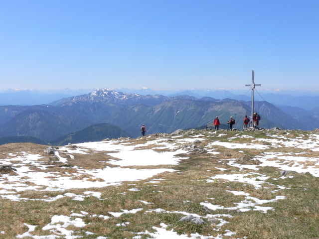
Der Gipfel bietet bei guten Wetter einen gewaltigen Ausblick, weshalb er sehr oft erklommen wird. Beim Abstieg bietet sich der kleine Ötscher als Tourverlängerung an. Ansonsten geht es vorbei am Ötscherschutzhaus und Schipisten zurück zum Parkplatz.
Der Gipfel bietet bei guten Wetter einen gewaltigen Ausblick, weshalb er sehr oft erklommen wird. Beim Abstieg bietet sich der kleine Ötscher als Tourverlängerung an. Ansonsten geht es vorbei am Ötscherschutzhaus und Schipisten zurück zum Parkplatz.
Further information at
http://de.wikipedia.org/wiki/ÖtscherGalerie du tour
Carte du tour et altitude
Minimum height 835 m
Maximum height 1894 m
More about the tour author
|
|
gerhardg |
Commentaires

Innkreisautobahn A 8 - Westautobahn A 1 – Abfahrt Ybbs-Erlauftal. B25 Wieselburg – Purgstall – Scheibbs in Richtung Gaming – Lackenhof - Weitental
Ausreichend Parkmöglichkeiten im Bereich des Skigebietes.
Ausreichend Parkmöglichkeiten im Bereich des Skigebietes.
Tracks GPS
Trackpoints-
GPX / Garmin Map Source (gpx) download
-
TCX / Garmin Training Center® (tcx) download
-
CRS / Garmin Training Center® (crs) download
-
Google Earth (kml) download
-
G7ToWin (g7t) download
-
TTQV (trk) download
-
Overlay (ovl) download
-
Fugawi (txt) download
-
Kompass (DAV) Track (tk) download
-
Feuille de tours (pdf) download
-
Original file of the author (gpx) download
More about the tour author
|
|
gerhardg |
Add to my favorites
Remove from my favorites
Edit tags
Open track
My score
Rate