
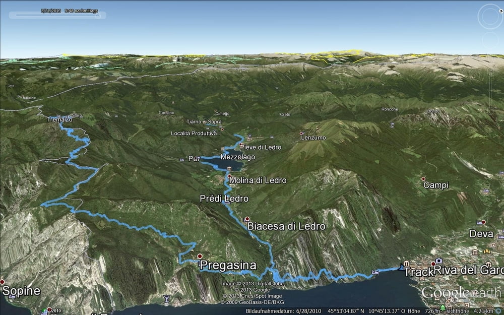

Von Riva die Ponalestrasse benutzend bis zum Abzweig Richtung Ledrosee. Auf Asphalt bis zur Strasse (Ende KfZ-Tunnel), dann ein kurzes Stück auf dieser (Haupt-)Strasse, links ab auf den Radweg zum Ledrosee. Linkerhand am See entlang dann in das Tal hinein. Immer auf dem Radweg bleibend bis zur Passstrasse rauf zum Tremalzo. Dann den langwierigen Teil: auf der asphaltierten Strasse bis zur bewirteten Hütte! Nach einer Stärkung beginnt der schönste Teil der Tour: rauf zum Tunnel (höchster Punkt der Tour) und dann durch und in den Schotter-Abfahrtsspass! Am Passo Nota angekommen weiter Richtung Passo Rocchetta (Alternativ Richtung Vecchio Corna und nach Vesio - Limone und mit Schiff zurück). Vom Rocchetta ab den Sentiero 422 (Fahrtechnik erforderlich! nichts für Anfänger!). Einmal muss man Absteigen und das Bike einen drop runtertragen ansonsten Wurzelpassagen im dichten Wald. In Pregasina angekommen, geht's die Ponalestrasse runter nach Riva.
Galerie du tour

Carte du tour et altitude
Minimum height 71 m
Maximum height 1835 m
More about the tour author
|
|
Micha-IN |
Commentaires

Tracks GPS
Trackpoints-
GPX / Garmin Map Source (gpx) download
-
TCX / Garmin Training Center® (tcx) download
-
CRS / Garmin Training Center® (crs) download
-
Google Earth (kml) download
-
G7ToWin (g7t) download
-
TTQV (trk) download
-
Overlay (ovl) download
-
Fugawi (txt) download
-
Kompass (DAV) Track (tk) download
-
Feuille de tours (pdf) download
-
Original file of the author (gpx) download
More about the tour author
|
|
Micha-IN |
Add to my favorites
Remove from my favorites
Edit tags
Open track
My score
Rate