Login

Login oublié ?

Cookies have to be accepted!
Your browser's cookie functionality is disabled. Please enable this functionality.

Not a member yet?

Register now
Login

Available for registred users only

Log in to use this feature.

Login oublié ?

Cookies have to be accepted!
Your browser's cookie functionality is disabled. Please enable this functionality.

Not a member yet?

Register now
Filter
Catégories
Advanced filters
  • Longueur (km)
  • Altimètre
Enregistrer le filtre Reset filter

TrackRank

QRCode

Technical data

Longueur18,0 km Altimètre729 m Way down734 m Durée00:00 h:m Date08.03.2014
Evaluations Author Paysage Aspect amusement Condition Technique

Statistiques

548 Vues Evaluations 42 Téléchargements Moyenne
Rate
  • Feuille de tours
  • Arrivée
  • Téléchargements

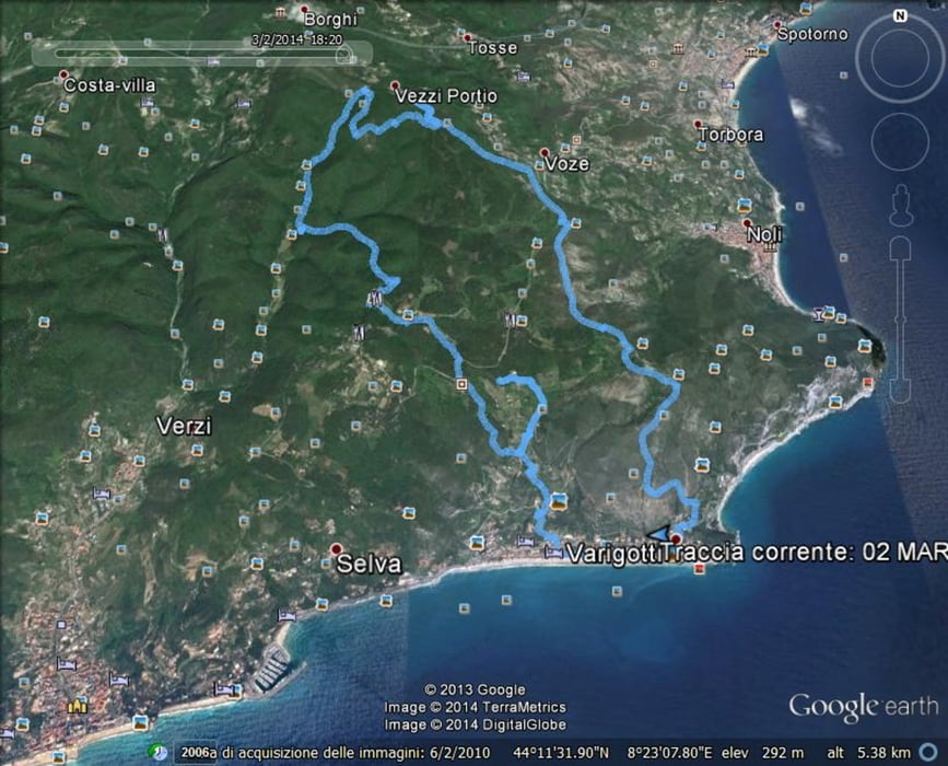
Varigotti- Pino - Isarco Arma delle Manie - P.te delle Voze P.te dell'Acqua- Colle  di Magnone 324 m.- Pra Antonino - Bric dei Monti 437m. - Bric dei Corvi 382 m. - Piano delle Streghe 266m - Territorio Indiano - Chiesa di San Lorenzo 105m. - Varigotti.

Itinerario escursionistico, archeologico, necropoli romana di Isasco, una parte dei Ponti Romani, Chiesa di San Lorenzo. Diversi punti panoramici. 


Carte du tour et altitude

  • Open Street Map
  • Google
Minimum height -2 m Maximum height 431 m Vue de détail

More about the tour author

miracc55
Member since 2013

Send private message

Commentaires

Varigotti (SV) , punto di partenza e arrivo

Tracks GPS

Trackpoints
  • GPX / Garmin Map Source (gpx) download
  • TCX / Garmin Training Center® (tcx) download
  • CRS / Garmin Training Center® (crs) download
  • Google Earth (kml) download
  • G7ToWin (g7t) download
  • TTQV (trk) download
  • Overlay (ovl) download
  • Fugawi (txt) download
  • Kompass (DAV) Track (tk) download
  • Feuille de tours (pdf) download
  • Original file of the author (gpx) download

More about the tour author

miracc55
Member since 2013

Send private message
Share track
Add to my favorites
Remove from my favorites
Edit tags
My score
Rate
Tour: Finalese Archeologico parte 3
Cat.: Tour en montagne
Longueur: 18,0 km
Evaluated on:
Durée:
Day(s)
Hour(s)
Minute(s)
Evaluation: Paysage Aspect amusement Condition Technique