Login

Login oublié ?

Cookies have to be accepted!
Your browser's cookie functionality is disabled. Please enable this functionality.

Not a member yet?

Register now
Login

Available for registred users only

Log in to use this feature.

Login oublié ?

Cookies have to be accepted!
Your browser's cookie functionality is disabled. Please enable this functionality.

Not a member yet?

Register now
Filter
Catégories
Advanced filters
  • Longueur (km)
  • Altimètre
Enregistrer le filtre Reset filter

TrackRank

QRCode

Technical data

Longueur37,2 km Altimètre202 m Way down202 m Durée00:00 h:m Date07.08.2015
Evaluations Author Paysage Aspect amusement Condition Technique

Statistiques

451 Vues Evaluations 54 Téléchargements Moyenne
Rate
  • Feuille de tours
  • Arrivée
  • Téléchargements

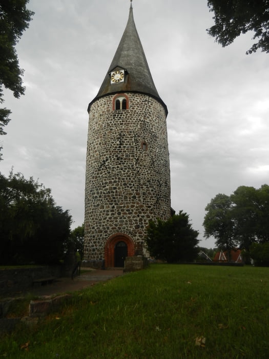
Radtour: Ausgangspunkt Hof Altona bei Sierksdorf.Gute Parkmöglichkeit an der Hauptstr./Am Pönitzer See(Naturschutzgebiet Klingberg) über Schürsdorf,Pansdorf,Ratekau. Wunderschone Rundkirche.Weiter über Hemmelsdorf,Timmendorfer Strand, Scharbeutz,Haffkrug und Sierksdorf.

Es ging immer hoch und runter auf Teerstraßen.

Carte du tour et altitude

  • Open Street Map
  • Google
Minimum height Maximum height 51 m Vue de détail

More about the tour author

florilein
Member since 2014

Send private message

Commentaires

Von der Autobahn aus Richtung Lübeck,Abfahrt Eutin,dann Richtung Sierksdorf. Aber vorher abbiegen nach Hof Altona.

Tracks GPS

Trackpoints
  • GPX / Garmin Map Source (gpx) download
  • TCX / Garmin Training Center® (tcx) download
  • CRS / Garmin Training Center® (crs) download
  • Google Earth (kml) download
  • G7ToWin (g7t) download
  • TTQV (trk) download
  • Overlay (ovl) download
  • Fugawi (txt) download
  • Kompass (DAV) Track (tk) download
  • Feuille de tours (pdf) download
  • Original file of the author (gpx) download

More about the tour author

florilein
Member since 2014

Send private message
Share track
Add to my favorites
Remove from my favorites
Edit tags
My score
Rate
Tour: Sierksdorf und Umgebung
Cat.: Randonnées
Longueur: 37,2 km
Evaluated on:
Durée:
Day(s)
Hour(s)
Minute(s)
Evaluation: Paysage Aspect amusement Condition Technique