Login

Login oublié ?

Cookies have to be accepted!
Your browser's cookie functionality is disabled. Please enable this functionality.

Not a member yet?

Register now
Login

Available for registred users only

Log in to use this feature.

Login oublié ?

Cookies have to be accepted!
Your browser's cookie functionality is disabled. Please enable this functionality.

Not a member yet?

Register now
Filter
Catégories
Advanced filters
  • Longueur (km)
  • Altimètre
Enregistrer le filtre Reset filter

TrackRank

QRCode

Technical data

Longueur53,6 km Altimètre1500 m Way down1155 m Durée07:30 h:m Date12.09.2016
Evaluations Author Paysage Aspect amusement Condition Technique

Statistiques

230 Vues Evaluations 44 Téléchargements Moyenne
Rate
  • Feuille de tours
  • Arrivée
  • Téléchargements
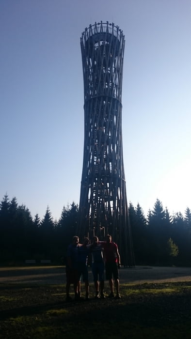
Die Tour geht vom Bahnhof in Freienohl durch den Arnsberger Wald in Richtung Brilon, bevor es hinauf nach Willingen geht. Es geht überwiegend über Waldwege und Pfade, nur kurze Abschnitte werden auf kleinen Straßen gefahren. Bei km 15 kommt man am Lörmecke Turm vorbei, die Aussicht oben sollte man nicht verpassen. Bei km 40 lädt die Hiebammen Hütte zur Stärkung ein, bevor es dann an den Aufstieg nach Willingen geht.

Galerie du tour

Carte du tour et altitude

  • Open Street Map
  • Google
Minimum height 233 m Maximum height 810 m Vue de détail

More about the tour author

RobTour
Member since 2012

Send private message

Commentaires

Tracks GPS

Trackpoints
  • GPX / Garmin Map Source (gpx) download
  • TCX / Garmin Training Center® (tcx) download
  • CRS / Garmin Training Center® (crs) download
  • Google Earth (kml) download
  • G7ToWin (g7t) download
  • TTQV (trk) download
  • Overlay (ovl) download
  • Fugawi (txt) download
  • Kompass (DAV) Track (tk) download
  • Feuille de tours (pdf) download
  • Original file of the author (gpx) download

More about the tour author

RobTour
Member since 2012

Send private message
Share track
Add to my favorites
Remove from my favorites
Edit tags
My score
Rate
Tour: Freienohl-Willingen
Cat.: Mountainbike
Longueur: 53,6 km
Evaluated on:
Durée:
Day(s)
Hour(s)
Minute(s)
Evaluation: Paysage Aspect amusement Condition Technique