


Tourendatum: 25.09.2016
Tourensteckbrief: Lange, konditionell anspruchsvolle Berg- und Klettersteigtour auf den höchsten Gipfel des Steinernen Meeres. Klettersteigschwierigkeit C-D. Insgesamt eine landschaftlich und klettertechnisch tolle Runde.
Gehzeiten:
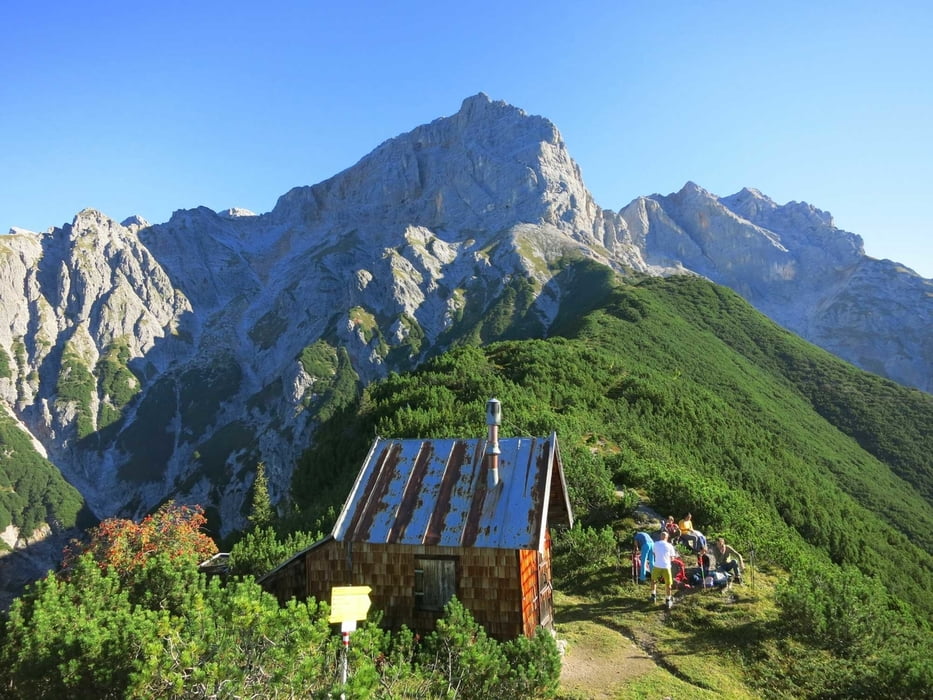
PP(900) - Braggstein - Einstieg (2250) : 2,5 - 3,5 Std.
Einstieg - Selbhorn-Südgipfel (2643): ca. 2Std. (400 Hm)
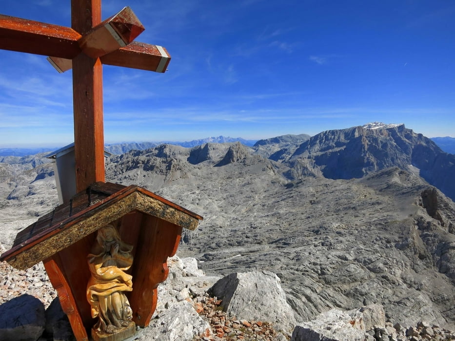
Südgipfel - Nordgipfel (2654): ca. 15 Min
D.h. Gesamtzeit Aufstieg: 4,5 - 6 Stdn.
Abstieg: Selbhorn-Nordgipfel - Luegscharte (2448): Ca. 0,5-1 Std.
Luegscharte - Buchauer Scharte (2270): 0,5 - 1 Std.
Buchauer Scharte - Freithofalm (1555) - PP: Ca. 2 - 2,5 Std.
D.h. Gesamtzeit Abstieg: 3 - 4 Std.
Gesamtzeit für die Tour: Ca. 7,5 - 10 Stdn.
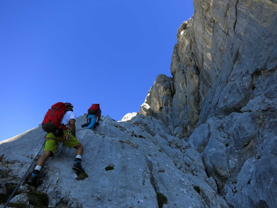
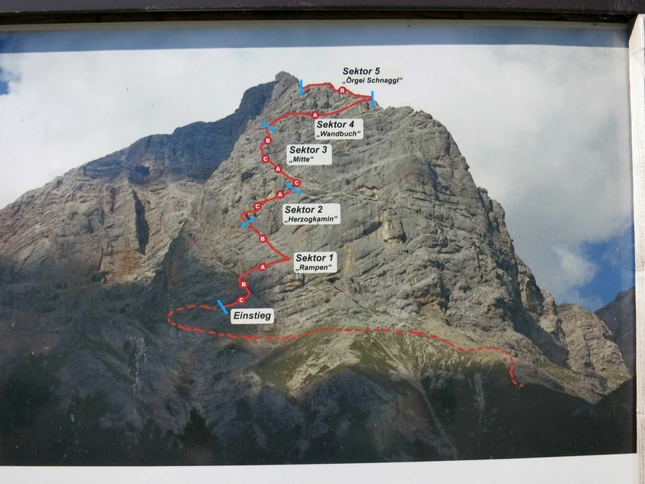
Hinweis zum Klettersteig: Der Steig ist in allen schwierigen Pasagen mit einem Stahlseil versichert, die leichten Passagen sind mit einem normalen Kletterseil gesichert. Es wechseln im Rhythmus schwierige und leichte Passagen, sodass man zwischendrin immer genug Zeit zum Rasten hat. Auf manchen Bändern auch Gehgelände. Insgesamt sehr schöne und abwechslungsreiche Kletterei mit tollen Ausblicken und schönen Tiefblicken.
Man sollte genügend zu Trinken dabei haben, letzte Wasserstelle im Aufstieg bei der Lechneralm (1261), dann erst wieder bei der Freithofalm (1555) im Abstieg !! An heissen Sommertagen kann das schnell zum Problem werden.
Further information at
https://photos.google.com/share/AF1QipPRCR8IOuRYU1tB8E2pFZHLBBv0FmAvlrMZZJBhRI2tj8uS2U_pF6tPbrJJotkERg?hl=de&key=Nm5YaWNwY2VXd0pWQlhydnVFdkYxUy1kNnA2QWlnGalerie du tour
Carte du tour et altitude
Minimum height 896 m
Maximum height 2656 m
More about the tour author
|
|
Eimy |
Commentaires

Autobahn A8 - Ausfahrt Traunstein/Inzell - Inzell - Lofer - Saalfelden. Links abbiegen nach Maria Alm, durch den Ort entlang dem Bach bis zum Fahrverbot beim Whs. Rohrmoos
Tracks GPS
Trackpoints-
GPX / Garmin Map Source (gpx) download
-
TCX / Garmin Training Center® (tcx) download
-
CRS / Garmin Training Center® (crs) download
-
Google Earth (kml) download
-
G7ToWin (g7t) download
-
TTQV (trk) download
-
Overlay (ovl) download
-
Fugawi (txt) download
-
Kompass (DAV) Track (tk) download
-
Feuille de tours (pdf) download
-
Original file of the author (gpx) download
More about the tour author
|
|
Eimy |
Add to my favorites
Remove from my favorites
Edit tags
Open track
My score
Rate