
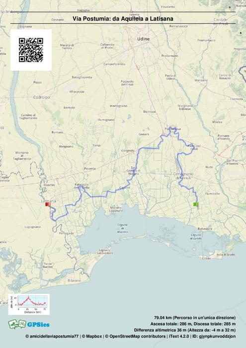

Aquileia può essere raggiunta avvicinandosi col treno a Cervignano del Friuli, da li si dovranno fare 7km sulla ciclabile o prendere il bus. Il Friuli è divisibile in 4 tappe, sono 79 km in piano. Da non perdere, Aquileia,Strassoldo,Aiello del Friuli, Palmanova,Bosco Baredi-Lupari,Latisana(presente stazione dei treni). nel link sotto trovate la traccia gpx da scaricare,altrimenti fate richiesta e la invieremo. La Prima Freccia gialla si trova nel cartello davanti all'ostello Domus Augusta,vicino alla Basilica invece è in terra nel vialetto di destra che conduce alla Via Sacra e al Porto Fluviale. buon cammino
Further information at
https://www.facebook.com/groups/319290031614676/?ref=bookmarksCarte du tour et altitude
Minimum height 3 m
Maximum height 25 m
More about the tour author

|
viapostumia |
Commentaires

Stazione Cervignano, bus oppure ciclabile.
Tracks GPS
Trackpoints-
GPX / Garmin Map Source (gpx) download
-
TCX / Garmin Training Center® (tcx) download
-
CRS / Garmin Training Center® (crs) download
-
Google Earth (kml) download
-
G7ToWin (g7t) download
-
TTQV (trk) download
-
Overlay (ovl) download
-
Fugawi (txt) download
-
Kompass (DAV) Track (tk) download
-
Feuille de tours (pdf) download
-
Original file of the author (gpx) download
More about the tour author
|
|
viapostumia |
Add to my favorites
Remove from my favorites
Edit tags
Open track
My score
Rate