Login

Login oublié ?

Cookies have to be accepted!
Your browser's cookie functionality is disabled. Please enable this functionality.

Not a member yet?

Register now
Login

Available for registred users only

Log in to use this feature.

Login oublié ?

Cookies have to be accepted!
Your browser's cookie functionality is disabled. Please enable this functionality.

Not a member yet?

Register now
Filter
Catégories
Advanced filters
  • Longueur (km)
  • Altimètre
Enregistrer le filtre Reset filter

TrackRank

QRCode

Technical data

Longueur3,8 km Altimètre295 m Way down99 m Durée03:00 h:m Date29.10.2017
Evaluations Author Paysage Aspect amusement Condition Technique

Statistiques

281 Vues Evaluations 17 Téléchargements Moyenne
Rate
  • Feuille de tours
  • Arrivée
  • Téléchargements
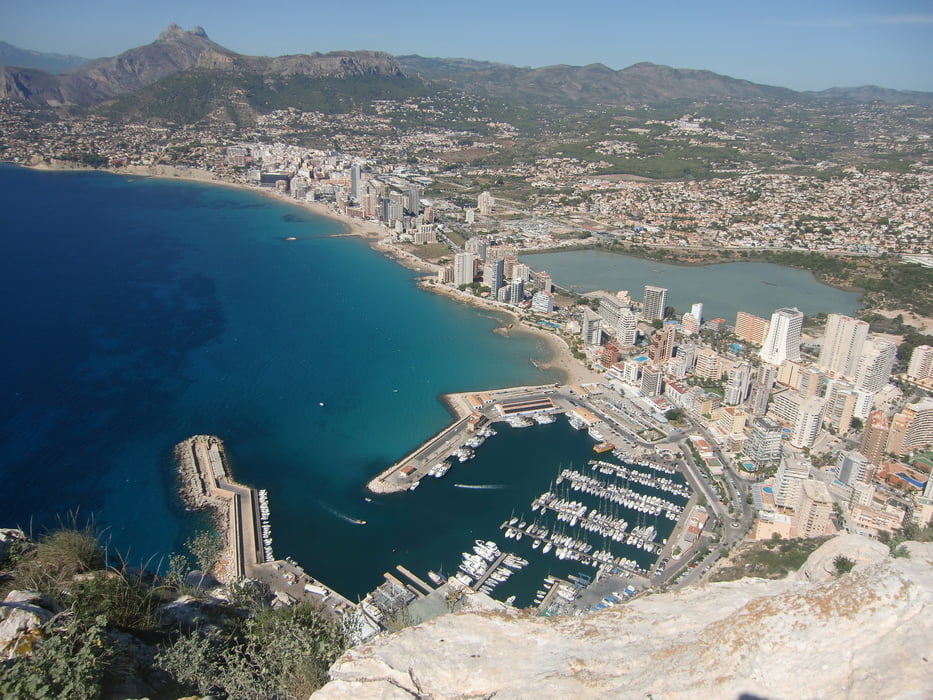
Die Tour führt auf das Wahrzeichen von Calpe. Vom Gipfel (327 m) hat man eine herrliche Aussicht auf den Ort. Eine Wegbeschreibung ist überflüssig. Der Wegverlauf ist eindeutig. Oberhalb des Hafens ist der Einstieg. Für die Besteigung ist festes Schuhwerk erforderlich!

Galerie du tour

Carte du tour et altitude

  • Open Street Map
  • Google
Minimum height 33 m Maximum height 330 m Vue de détail

More about the tour author

ruf_markus
Member since 2008

Send private message

Commentaires

Tracks GPS

Trackpoints
  • GPX / Garmin Map Source (gpx) download
  • TCX / Garmin Training Center® (tcx) download
  • CRS / Garmin Training Center® (crs) download
  • Google Earth (kml) download
  • G7ToWin (g7t) download
  • TTQV (trk) download
  • Overlay (ovl) download
  • Fugawi (txt) download
  • Kompass (DAV) Track (tk) download
  • Feuille de tours (pdf) download
  • Original file of the author (gpx) download

More about the tour author

ruf_markus
Member since 2008

Send private message
Share track
Add to my favorites
Remove from my favorites
Edit tags
My score
Rate
Tour: Penyal d'Ifac
Cat.: Randonnées
Longueur: 3,8 km
Evaluated on:
Durée:
Day(s)
Hour(s)
Minute(s)
Evaluation: Paysage Aspect amusement Condition Technique