


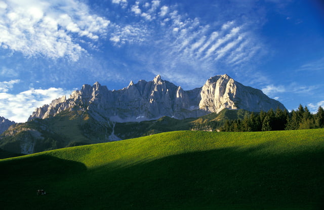
Der Kaiserblickweg führt durch ein sagenumwobenes und geologisch wertvolles Gebiet. Außerdem bietet er Wanderern ein herrliches Panorama auf die zwei markantesten Gebirgsketten der Region: den Wilden Kaiser und den Zahmen Kaiser. Das mystische und sagenumwobene Kaisergebirge ist eine Gebirgsgruppe der Nördlichen Kalkalpen in den Ostalpen. Es befindet sich zur Gänze im Bundesland Tirol und ist ein beliebtes Wander- und Klettergebiet.
Further information at
http://touren.kitzbuehel.comGalerie du tour
Carte du tour et altitude
Minimum height 769 m
Maximum height 828 m
More about the tour author
|
|
Kitzbuehel |
Commentaires

Kulturhaus Reith – Kirche – Schilift – über Wiesenweg zur Veitlkapelle – Wirtsalm – über Almweg zur Scharlwandalm – über Serpentinen zur Höhenangeralm – Richtung Auer Niederalm – Kaiserblick – Rauher Kopf – Gebirgsbrunnen – Forststraße Richtung Kirchberg – Jausenstation Hennleiten.
Tracks GPS
Trackpoints-
GPX / Garmin Map Source (gpx) download
-
TCX / Garmin Training Center® (tcx) download
-
CRS / Garmin Training Center® (crs) download
-
Google Earth (kml) download
-
G7ToWin (g7t) download
-
TTQV (trk) download
-
Overlay (ovl) download
-
Fugawi (txt) download
-
Kompass (DAV) Track (tk) download
-
Feuille de tours (pdf) download
-
Original file of the author (gpx) download
More about the tour author
|
|
Kitzbuehel |
Add to my favorites
Remove from my favorites
Edit tags
Open track
My score
Rate