Login

Login oublié ?

Cookies have to be accepted!
Your browser's cookie functionality is disabled. Please enable this functionality.

Not a member yet?

Register now
Login

Available for registred users only

Log in to use this feature.

Login oublié ?

Cookies have to be accepted!
Your browser's cookie functionality is disabled. Please enable this functionality.

Not a member yet?

Register now
Filter
Catégories
Advanced filters
  • Longueur (km)
  • Altimètre
Enregistrer le filtre Reset filter

TrackRank

QRCode

Technical data

Longueur12,6 km Altimètre0 m Way down0 m Durée01:45 h:m Date02.07.2008
Evaluations Author Paysage Aspect amusement Condition Technique

Statistiques

565 Vues 1 Evaluation 89 Téléchargements 3.00 Moyenne
Rate
  • Feuille de tours
  • Arrivée
  • Téléchargements

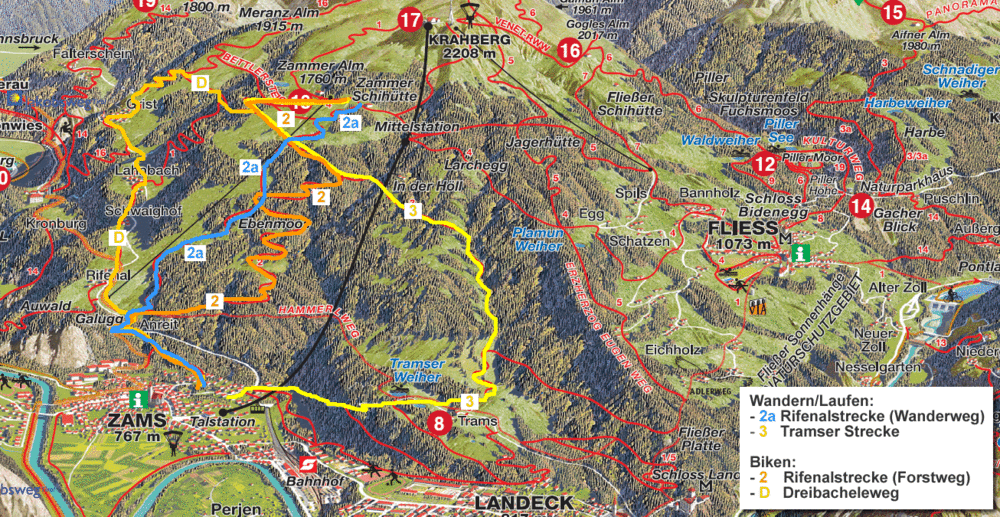
Die Tour startet bei den Venet Bergbahnen in Landeck/Zams.

Wegbeschreibung: Gemeindestraße bis nach Grist, dann abzweigen auf die Forststraße in Richtung Maranzer Alm bis zur Abzweigung in Richtung Zamser Schihütte, dann über den Lanbachweg zum Weinberglift und zur Schihütte

Further information at

http://www.gpsfox.at

Galerie du tour

Carte du tour et altitude

  • Open Street Map
  • Google
Minimum height 99999 m Maximum height -99999 m Vue de détail

More about the tour author

Chris07
Member since 2008

Send private message

Commentaires

Autobahn A12 - Abfahrt Landeck/Zams, Schildern in Richtung Zams bzw. zu den Venet Bergbahnen folgen

Tracks GPS

Trackpoints
  • GPX / Garmin Map Source (gpx) download
  • TCX / Garmin Training Center® (tcx) download
  • CRS / Garmin Training Center® (crs) download
  • Google Earth (kml) download
  • G7ToWin (g7t) download
  • TTQV (trk) download
  • Overlay (ovl) download
  • Fugawi (txt) download
  • Kompass (DAV) Track (tk) download
  • Feuille de tours (pdf) download
  • Original file of the author (gpx) download

More about the tour author

Chris07
Member since 2008

Send private message
Share track
Add to my favorites
Remove from my favorites
Edit tags
My score
Rate
Tour: Venet Trophy - Dreibacheleweg
Cat.: Mountainbike
Longueur: 12,6 km
Evaluated on:
Durée:
Day(s)
Hour(s)
Minute(s)
Evaluation: Paysage Aspect amusement Condition Technique