Login

Login oublié ?

Cookies have to be accepted!
Your browser's cookie functionality is disabled. Please enable this functionality.

Not a member yet?

Register now
Login

Available for registred users only

Log in to use this feature.

Login oublié ?

Cookies have to be accepted!
Your browser's cookie functionality is disabled. Please enable this functionality.

Not a member yet?

Register now
Filter
Catégories
Advanced filters
  • Longueur (km)
  • Altimètre
Enregistrer le filtre Reset filter

TrackRank

QRCode

Technical data

Longueur86,6 km Altimètre668 m Way down768 m Durée05:30 h:m Date14.12.2008
Evaluations Author Paysage Aspect amusement Condition Technique

Statistiques

213 Vues Evaluations 30 Téléchargements Moyenne
Rate
  • Feuille de tours
  • Arrivée
  • Téléchargements
Tour von Gladbeck über Dorsten in die Hohe Mark. Dort ein paar Schleifen gedreht (Sorry, an einer Stelle ist uns der Weg ausgegangen, so dass wir rund 300 m gewandert sind) und anschließend über Haltern, Marl wieder zurück.

Galerie du tour

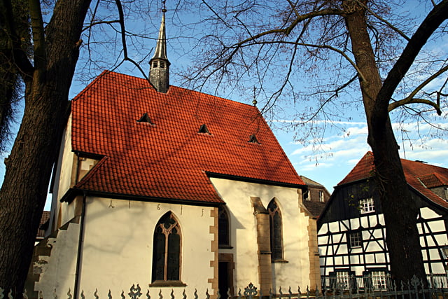
Carte du tour et altitude

  • Open Street Map
  • Google
Minimum height 26 m Maximum height 170 m Vue de détail

More about the tour author

tottreter
Member since 2006

Send private message

Commentaires

Tracks GPS

Trackpoints
  • GPX / Garmin Map Source (gpx) download
  • TCX / Garmin Training Center® (tcx) download
  • CRS / Garmin Training Center® (crs) download
  • Google Earth (kml) download
  • G7ToWin (g7t) download
  • TTQV (trk) download
  • Overlay (ovl) download
  • Fugawi (txt) download
  • Kompass (DAV) Track (tk) download
  • Feuille de tours (pdf) download
  • Original file of the author (gpx) download

More about the tour author

tottreter
Member since 2006

Send private message
Share track
Add to my favorites
Remove from my favorites
Edit tags
My score
Rate
Tour: Hohe Mark
Cat.: Mountainbike
Longueur: 86,6 km
Evaluated on:
Durée:
Day(s)
Hour(s)
Minute(s)
Evaluation: Paysage Aspect amusement Condition Technique