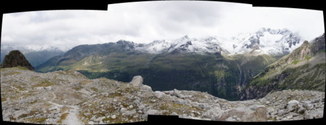
Bellissima escursione da Riva di Tures - Rein sino al rifugio Roma ed olre sino a lambire il ghiacciaio Rieserferner molto ridotto all'estate 2008.
Dal grande parcheggio (gratuito) di Rein si segue diritti il bel sentiero n.1 che porta, attraverso boschi e radure molto panoramiche con pascoli attivi sino al Rif. Roma.Salendo si incontra il sentiero n.8b che proviene più ripido dal fondovalle.
Noi siamo saliti oltre il rifugio, aggirando all'andata il bel Tristennhockl verso nord-ovest fuori sentiero e quindi salendo per morene sino alla ex stazione meteorologica (in disuso al 2008)
Ritornati al rifugio seguendo il sentiero tradizionale che scorre ad est del Tristennhockl, siamo ritornati a valle calando per il sentiero n.8b che avevamo incontrato salendo.Il ritorno al park avviene per stradine forestali e poi per un tratto di 1km di strada asfaltata.
Il paesaggio è incantevole, i sentieri sono ben battuti e segnati, quì è bello anche per sci-alpinismo.
Cartografia TABACCO nr.35 Ahrntal-Valle Aurina Vedrette di Ries-RieserFerner Gruppe :25000 GPS-UTM
Galerie du tour
Carte du tour et altitude
Commentaires

Tracks GPS
Trackpoints-
GPX / Garmin Map Source (gpx) download
-
TCX / Garmin Training Center® (tcx) download
-
CRS / Garmin Training Center® (crs) download
-
Google Earth (kml) download
-
G7ToWin (g7t) download
-
TTQV (trk) download
-
Overlay (ovl) download
-
Fugawi (txt) download
-
Kompass (DAV) Track (tk) download
-
Feuille de tours (pdf) download
-
Original file of the author (gpx) download


