Login

Login oublié ?

Cookies have to be accepted!
Your browser's cookie functionality is disabled. Please enable this functionality.

Not a member yet?

Register now
Login

Available for registred users only

Log in to use this feature.

Login oublié ?

Cookies have to be accepted!
Your browser's cookie functionality is disabled. Please enable this functionality.

Not a member yet?

Register now
Filter
Catégories
Advanced filters
  • Longueur (km)
  • Altimètre
Enregistrer le filtre Reset filter

TrackRank

QRCode

Technical data

Longueur107,4 km Altimètre859 m Way down902 m Durée04:27 h:m Date30.12.2009
Evaluations Author Paysage Aspect amusement Condition Technique

Statistiques

1204 Vues 1 Evaluation 148 Téléchargements 4.00 Moyenne
Rate
  • Feuille de tours
  • Arrivée
  • Téléchargements

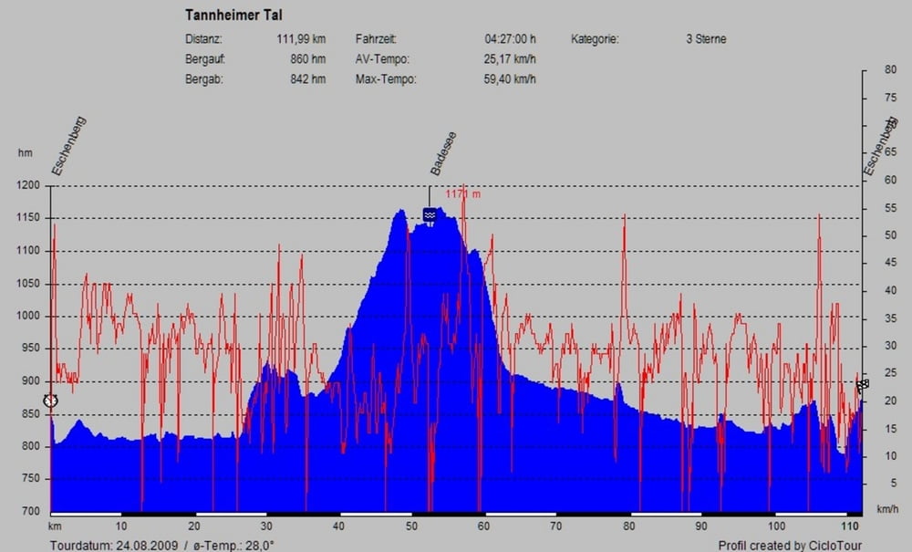
Wunderschöne Rennradtour von Eschenberg (D) nach Östereich durch das Tannheimer Tal zurück nach Eschenberg bei Halblech. Gute Straßen, wenig Verkehr. Bitte im Sommer die Badesachen nicht vergessen.

Galerie du tour

Carte du tour et altitude

  • Open Street Map
  • Google
Minimum height 759 m Maximum height 1151 m Vue de détail

More about the tour author

pinarello1
Member since 2008

Send private message

Commentaires

Tracks GPS

Trackpoints
  • GPX / Garmin Map Source (gpx) download
  • TCX / Garmin Training Center® (tcx) download
  • CRS / Garmin Training Center® (crs) download
  • Google Earth (kml) download
  • G7ToWin (g7t) download
  • TTQV (trk) download
  • Overlay (ovl) download
  • Fugawi (txt) download
  • Kompass (DAV) Track (tk) download
  • Feuille de tours (pdf) download
  • Original file of the author (gpx) download

More about the tour author

pinarello1
Member since 2008

Send private message
Share track
Add to my favorites
Remove from my favorites
Edit tags
My score
Rate
Tour: Tannheimer Tal
Cat.: Vélo de course
Longueur: 107,4 km
Evaluated on:
Durée:
Day(s)
Hour(s)
Minute(s)
Evaluation: Paysage Aspect amusement Condition Technique