Login

Login oublié ?

Cookies have to be accepted!
Your browser's cookie functionality is disabled. Please enable this functionality.

Not a member yet?

Register now
Login

Available for registred users only

Log in to use this feature.

Login oublié ?

Cookies have to be accepted!
Your browser's cookie functionality is disabled. Please enable this functionality.

Not a member yet?

Register now
Filter
Catégories
Advanced filters
  • Longueur (km)
  • Altimètre
Enregistrer le filtre Reset filter

TrackRank

QRCode

Technical data

Longueur11,4 km Altimètre209 m Way down209 m Durée02:00 h:m Date12.01.2010
Evaluations Author Paysage Aspect amusement Condition Technique

Statistiques

238 Vues Evaluations 28 Téléchargements Moyenne
Rate
  • Feuille de tours
  • Arrivée
  • Téléchargements

Nocni bezky, do faktoru zabavy krajina jsem chtel napsat "n/a" ale neni na vyber. Nebylo nic videt:-)

Z Cinovce dolu k Rehefeldu a zpet podel hranice z CR, okolo biatlonistickych okruhu.

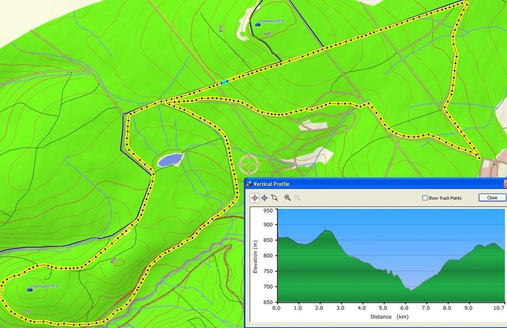
Carte du tour et altitude

  • Open Street Map
  • Google
Minimum height 714 m Maximum height 872 m Vue de détail

More about the tour author

Listansky
Member since 2009

Send private message

Commentaires

Tracks GPS

Trackpoints
  • GPX / Garmin Map Source (gpx) download
  • TCX / Garmin Training Center® (tcx) download
  • CRS / Garmin Training Center® (crs) download
  • Google Earth (kml) download
  • G7ToWin (g7t) download
  • TTQV (trk) download
  • Overlay (ovl) download
  • Fugawi (txt) download
  • Kompass (DAV) Track (tk) download
  • Feuille de tours (pdf) download
  • Original file of the author (gpx) download

More about the tour author

Listansky
Member since 2009

Send private message
Share track
Add to my favorites
Remove from my favorites
Edit tags
My score
Rate
Tour: Cinovec_Rehefeld
Cat.: Ski de fond
Longueur: 11,4 km
Evaluated on:
Durée:
Day(s)
Hour(s)
Minute(s)
Evaluation: Paysage Aspect amusement Condition Technique