


Vom Startpunkt aus geht es an der zwar auch hier viel befahrenen GC 500 direkt an der Küste entlang. Viele atemberaubende Ausblicke entschädigen für die anderen Verkehrsteilnehmer.
Bevor es in die Berge geht unbedingt einen Astecher zum Puerto de Mogan unternehemen. Ein Caffe con Leche am Strand bereitet auf das was noch kommt vor :-)
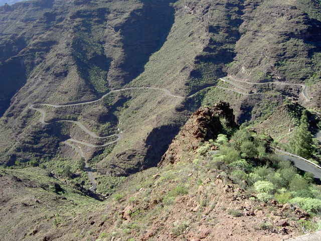
Der Aufstieg bis zum Cruz de San Antonio ist meist nicht zu steil. Man glaubt sich jedoc bald in alpinem Gelände, zu schön ziehen sich die Serpentinen nach oben.
Am Cruz de San Antonio ann man wählen. Entweder über San Bartolome und Fataga einwärts oder wie wir es wählten über Barranqillo. Es kommt halt drauf an, was für Turen man sonst noch fahren möchte oder schon gefahren hat. Bei unser Variante muss man ab Arguineguin wieder ein Stück des Weges fahren auf dem man gestartet ist.
Bevor es in die Berge geht unbedingt einen Astecher zum Puerto de Mogan unternehemen. Ein Caffe con Leche am Strand bereitet auf das was noch kommt vor :-)
Der Aufstieg bis zum Cruz de San Antonio ist meist nicht zu steil. Man glaubt sich jedoc bald in alpinem Gelände, zu schön ziehen sich die Serpentinen nach oben.
Am Cruz de San Antonio ann man wählen. Entweder über San Bartolome und Fataga einwärts oder wie wir es wählten über Barranqillo. Es kommt halt drauf an, was für Turen man sonst noch fahren möchte oder schon gefahren hat. Bei unser Variante muss man ab Arguineguin wieder ein Stück des Weges fahren auf dem man gestartet ist.
Galerie du tour
Carte du tour et altitude
Minimum height -13 m
Maximum height 929 m
More about the tour author
|
|
Burli |
Commentaires

Playa de Ingles oder Maspalomas
Tracks GPS
Trackpoints-
GPX / Garmin Map Source (gpx) download
-
TCX / Garmin Training Center® (tcx) download
-
CRS / Garmin Training Center® (crs) download
-
Google Earth (kml) download
-
G7ToWin (g7t) download
-
TTQV (trk) download
-
Overlay (ovl) download
-
Fugawi (txt) download
-
Kompass (DAV) Track (tk) download
-
Feuille de tours (pdf) download
-
Original file of the author (g7t) download
More about the tour author
|
|
Burli |
Add to my favorites
Remove from my favorites
Edit tags
Open track
My score
Rate