Login

Login oublié ?

Cookies have to be accepted!
Your browser's cookie functionality is disabled. Please enable this functionality.

Not a member yet?

Register now
Login

Available for registred users only

Log in to use this feature.

Login oublié ?

Cookies have to be accepted!
Your browser's cookie functionality is disabled. Please enable this functionality.

Not a member yet?

Register now
Filter
Catégories
Advanced filters
  • Longueur (km)
  • Altimètre
Enregistrer le filtre Reset filter

TrackRank

QRCode

Technical data

Longueur75,8 km Altimètre1861 m Way down1879 m Durée06:00 h:m Date17.07.2004
Evaluations Author Paysage Aspect amusement Condition Technique

Statistiques

4128 Vues Evaluations 606 Téléchargements Moyenne
Rate
  • Feuille de tours
  • Arrivée
  • Téléchargements
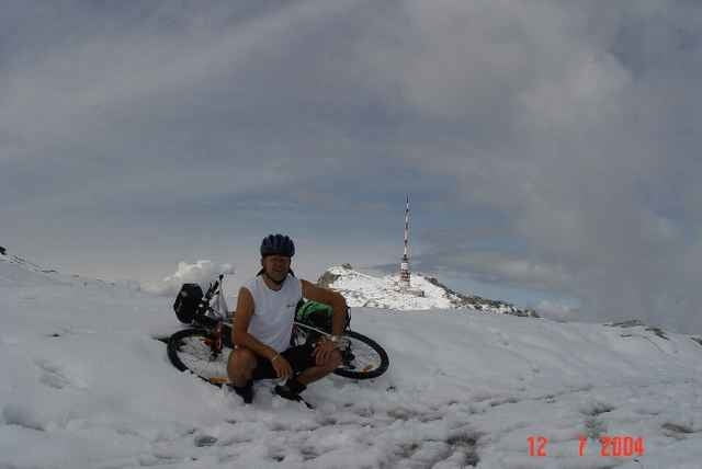
Sehr schwere Tour! Am dem Tag hatte ich teilweise bis zu 30 cm Neuschnee zu bewältigen, tragen war angesagt. Nasses Schuhwerk. Für das super Panorama hat es sich gelohnt!

Galerie du tour

Carte du tour et altitude

  • Open Street Map
  • Google
Minimum height 492 m Maximum height 2165 m Vue de détail

More about the tour author

Herbert
Member since 2004

Send private message

Commentaires

Tracks GPS

Trackpoints
  • GPX / Garmin Map Source (gpx) download
  • TCX / Garmin Training Center® (tcx) download
  • CRS / Garmin Training Center® (crs) download
  • Google Earth (kml) download
  • G7ToWin (g7t) download
  • TTQV (trk) download
  • Overlay (ovl) download
  • Fugawi (txt) download
  • Kompass (DAV) Track (tk) download
  • Feuille de tours (pdf) download
  • Original file of the author (g7t) download

More about the tour author

Herbert
Member since 2004

Send private message
Share track
Add to my favorites
Remove from my favorites
Edit tags
My score
Rate
Tour: Dobratsch
Cat.: Mountainbike
Longueur: 75,8 km
Evaluated on:
Durée:
Day(s)
Hour(s)
Minute(s)
Evaluation: Paysage Aspect amusement Condition Technique