Login

Login oublié ?

Cookies have to be accepted!
Your browser's cookie functionality is disabled. Please enable this functionality.

Not a member yet?

Register now
Login

Available for registred users only

Log in to use this feature.

Login oublié ?

Cookies have to be accepted!
Your browser's cookie functionality is disabled. Please enable this functionality.

Not a member yet?

Register now
Filter
Catégories
Advanced filters
  • Longueur (km)
  • Altimètre
Enregistrer le filtre Reset filter

TrackRank

QRCode

Technical data

Longueur34,7 km Altimètre431 m Way down m Durée00:00 h:m Date19.04.2007
Evaluations Author Paysage Aspect amusement Condition Technique

Statistiques

1579 Vues 1 Evaluation 261 Téléchargements 4.00 Moyenne
Rate
  • Feuille de tours
  • Arrivée
  • Téléchargements

Galerie du tour

Carte du tour et altitude
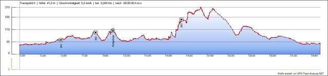
  • Open Street Map
  • Google
Minimum height 41 m Maximum height 210 m Vue de détail

More about the tour author

nomixs

Commentaires

Tobias on 23.05.2008

Ich bin die Strecke gestern zusammen mit einem Freund gefahren. Hat mir sehr gut gefallen, besonders der Teil um "Waypoint 003". Man sollte die Strecke allerdings im Uhrzeigersinn fahren, da die Wald-Abfahrt dann richtig ab geht :-)

Tracks GPS

Trackpoints
  • GPX / Garmin Map Source (gpx) download
  • TCX / Garmin Training Center® (tcx) download
  • CRS / Garmin Training Center® (crs) download
  • Google Earth (kml) download
  • G7ToWin (g7t) download
  • TTQV (trk) download
  • Overlay (ovl) download
  • Fugawi (txt) download
  • Kompass (DAV) Track (tk) download
  • Feuille de tours (pdf) download
  • Original file of the author (gpx) download

More about the tour author

nomixs

Share track
Add to my favorites
Remove from my favorites
Edit tags
My score
Rate
Tour: Leichlingen-Solingen-Hilden
Cat.: Mountainbike
Longueur: 34,7 km
Evaluated on:
Durée:
Day(s)
Hour(s)
Minute(s)
Evaluation: Paysage Aspect amusement Condition Technique