


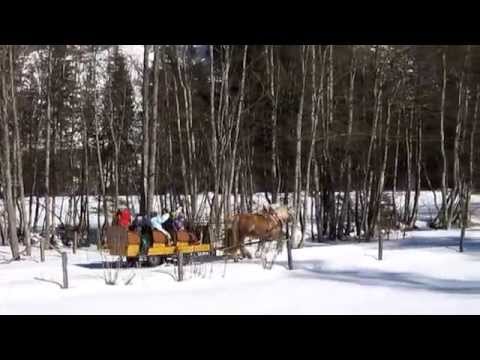
Die Silberstein - Loipe im Rohrmooser Obertal beginnt kurz nach der Abzweigung von der Tälerstraße bei der ersten Kehre (braune Linie in der Google Map). Die nur an einigen kurzen Abschnitten mittelschwere Loipe beginnt mit einer kleinen Abfahrt und führt dann 7,4 Kilometer weiter ins Obertal hinein bis nach Hopfriesen. Hin- und zurück sind auf dieser sehr abwechslungsreichen, klassischen Loipe 203 Höhenmeter zu bewältigen.
Mehr Infos, Fotos und Video findest du auf biketours4you.at
The silver stone – cross-country skiing trail in Rohrmoos-Obertal begins shortly after the junction near the first hairpin (brown line on the Google Map). The only a few short sections medium track begins with a small drop and then runs 7.4 kilometers further into the upper valley until the area - Hopfriesen. This diverse, classic cross-country skiing trail is waiting for you with 203 altimeters.
More infos, photos and video you'll see on biketours4you.at
Galerie du tour

Carte du tour et altitude
Minimum height 929 m
Maximum height 1074 m
More about the tour author
|
|
Trek1400d |
Commentaires

Tracks GPS
Trackpoints-
GPX / Garmin Map Source (gpx) download
-
TCX / Garmin Training Center® (tcx) download
-
CRS / Garmin Training Center® (crs) download
-
Google Earth (kml) download
-
G7ToWin (g7t) download
-
TTQV (trk) download
-
Overlay (ovl) download
-
Fugawi (txt) download
-
Kompass (DAV) Track (tk) download
-
Feuille de tours (pdf) download
-
Original file of the author (gpx) download
More about the tour author
|
|
Trek1400d |
Add to my favorites
Remove from my favorites
Edit tags
Open track
My score
Rate