Login

Login oublié ?

Cookies have to be accepted!
Your browser's cookie functionality is disabled. Please enable this functionality.

Not a member yet?

Register now
Login

Available for registred users only

Log in to use this feature.

Login oublié ?

Cookies have to be accepted!
Your browser's cookie functionality is disabled. Please enable this functionality.

Not a member yet?

Register now
Filter
Catégories
Advanced filters
  • Longueur (km)
  • Altimètre
Enregistrer le filtre Reset filter

TrackRank

QRCode

Technical data

Longueur34,1 km Altimètre486 m Way down460 m Durée03:00 h:m Date13.09.2011
Evaluations Author Paysage Aspect amusement Condition Technique

Statistiques

632 Vues Evaluations 37 Téléchargements Moyenne
Rate
  • Feuille de tours
  • Arrivée
  • Téléchargements


Leider am Anfang etwas Straßenlastig, da wir in Leichlingen falsch abgebogen sind. Der erste Teil nach Burscheid hoch lässt sich auch durh schöneres ersetzen (siehe unsere andere Burscheid Tour vom 11.08.2011).

In Burscheid kommt oben am Thomashof der technische Teil runter nach Altenberg und Co.

Insgesamt relativ viel Straßenanteil aber trotzdem eine sehr schöne Landschaft - wenn man nicht gerade p..nass wird ;-)


Galerie du tour

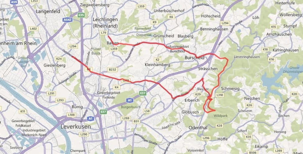
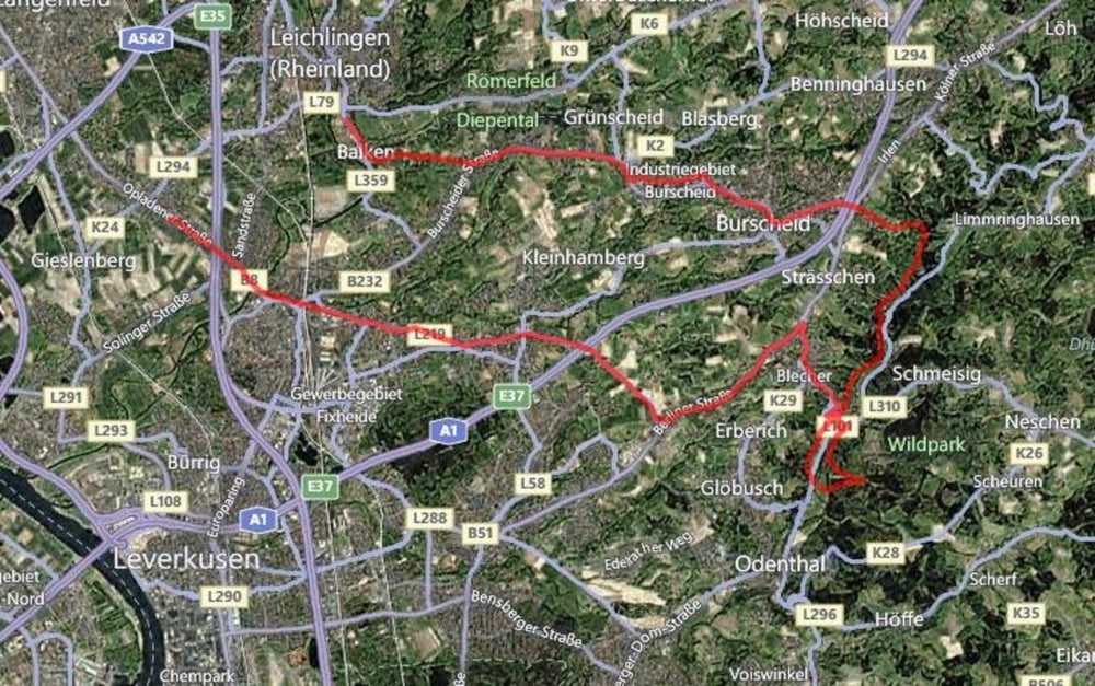
Carte du tour et altitude
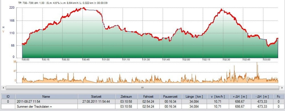
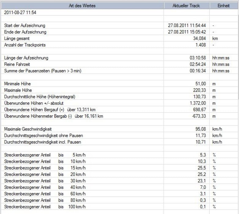
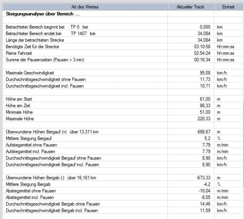
  • Open Street Map
  • Google
Minimum height 51 m Maximum height 220 m Vue de détail

More about the tour author

TrailRidersRheinland
Member since 2011

Send private message

Commentaires

Tracks GPS

Trackpoints
  • GPX / Garmin Map Source (gpx) download
  • TCX / Garmin Training Center® (tcx) download
  • CRS / Garmin Training Center® (crs) download
  • Google Earth (kml) download
  • G7ToWin (g7t) download
  • TTQV (trk) download
  • Overlay (ovl) download
  • Fugawi (txt) download
  • Kompass (DAV) Track (tk) download
  • Feuille de tours (pdf) download
  • Original file of the author (gpx) download

More about the tour author

TrailRidersRheinland
Member since 2011

Send private message
Share track
Add to my favorites
Remove from my favorites
Edit tags
My score
Rate
Tour: Langenfeld-Leichlingen-Burscheid-Blecher-Pampa-Leverkusen-Langenfeld
Cat.: Mountainbike
Longueur: 34,1 km
Evaluated on:
Durée:
Day(s)
Hour(s)
Minute(s)
Evaluation: Paysage Aspect amusement Condition Technique