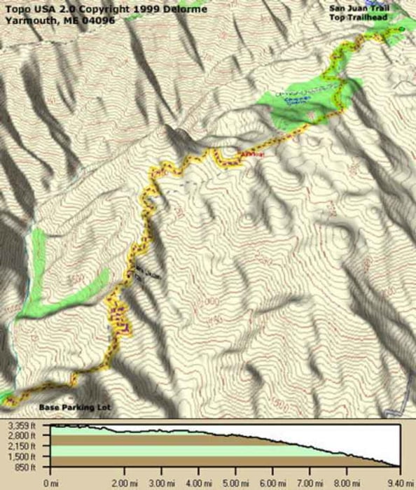
This is a 3 hour ride, if you run a shuttle, 6-7 hours otherwise. Start at the top and ride down, 2500 vertical feet, to the bottom, so check your brakes before the ride. 90% of the ride is singletrack on the edge of the canyon. Don't take any outside blind curves too fast or you may end up testing your parachute. You brought one, didn't you?
Further information at
http://www.raidoh.comMapa trasy i profil wysokości
Minimum height 243 m
Maximum height 999 m
Komentarze

Off the 5 freeway, take Ortega Highway East 9 miles. Take a left just before the Ranger Station. There is a sign for a rather large camp. Go 4 miles and park on the left by the Park bathrooms. The trails are the switchbacks just across the road you drove in on. To run shuttle, take the Ortega Highway another 9 miles east and take a left at the BlueJay Campground. Follow signs for the camp. Just past the entrance, 2.5 miles, is a parking lot with the trailhead right there. Just before the camp entrance is a second lot for overflow parking.
GPS tracks
Trackpoints-
GPX / Garmin Map Source (gpx) download
-
TCX / Garmin Training Center® (tcx) download
-
CRS / Garmin Training Center® (crs) download
-
Google Earth (kml) download
-
G7ToWin (g7t) download
-
TTQV (trk) download
-
Overlay (ovl) download
-
Fugawi (txt) download
-
Kompass (DAV) Track (tk) download
-
Karta trasy (pdf) download
-
Original file of the author (g7t) download
Add to my favorites
Remove from my favorites
Edit tags
Open track
My score
Rate


