Login

Zapomniałeś swój login?

Cookies have to be accepted!
Your browser's cookie functionality is disabled. Please enable this functionality.

Not a member yet?

Register now
Login

Available for registred users only

Log in to use this feature.

Zapomniałeś swój login?

Cookies have to be accepted!
Your browser's cookie functionality is disabled. Please enable this functionality.

Not a member yet?

Register now
Filter
Kategorie
Advanced filters
  • Długość (km)
  • Wysokość
Zapisz filtr Reset filter

TrackRank

QRCode

Technical data

Długość103,7 km Wysokość2857 m Way down2799 m Czas trwania07:52 h:m Data21.09.2007
Oceny Author Krajobraz Czynnik zadowolenia Kondycja Technika

Statystyka

2542 Widoki 1 Ocena 439 Downloads / Pliki do pobrania 4.00 Przeciętnie
Rate
  • Karta trasy
  • Dojazd
  • Downloads / Pliki do pobrania
Lech-Oberlech-Au-Schönebach-Sbratsgfäll-Obersdorf-Schrofenpass-Lechleiten-Warth-Lech

Mapa trasy i profil wysokości

  • Open Street Map
  • Google
Minimum height 805 m Maximum height 1783 m Widok szczegółowy

More about the tour author

1982452
Member since 2006

Send private message

Komentarze

Christian Fink on 23.09.2007

an einem Tag?

Hi!
Bist du das an einem Tag durchgefahren? Dann höchsten Respekt
1982452 on 14.06.2008

an einem Tag

ja bin die tour an einem Tag gefahren.
Schotten on 14.08.2009

hi!

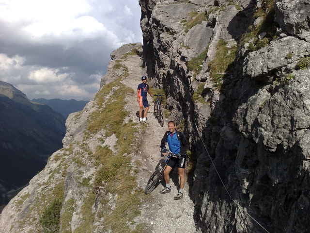
strecke klingt sehr interessant! wie sind die trails so bzw. gibt es viele single trails und wenn ja welche schwierigkeit so? eher leichtere oder heftige? danke vielmals!!!

beste grüße, daniel
opalmantra on 24.09.2011

schwierigkeit

hallo , du hast die schwierigkeit mit 5 angegeben , frage, kannst du mir das in der S skala angeben , ist es sehr verblockt , möchte es nur einordnen können nicht das es bergab nacher zu einfach wird , mögen es gerne ziemlich schwierig.das heist spitzkehren , 0,5m absätze geröll sehr wurzelig gruss aus aalen

GPS tracks

Trackpoints
  • GPX / Garmin Map Source (gpx) download
  • TCX / Garmin Training Center® (tcx) download
  • CRS / Garmin Training Center® (crs) download
  • Google Earth (kml) download
  • G7ToWin (g7t) download
  • TTQV (trk) download
  • Overlay (ovl) download
  • Fugawi (txt) download
  • Kompass (DAV) Track (tk) download
  • Karta trasy (pdf) download
  • Original file of the author (gpx) download

More about the tour author

1982452
Member since 2006

Send private message
Share track
Add to my favorites
Remove from my favorites
Edit tags
My score
Rate
Trasa: Lech Klein Walsertal Runde
Rodzaj: Rower górski (MTB)
Długość: 103,7 km
Evaluated on:
Czas trwania:
Day(s)
Hour(s)
Minute(s)
Ocena: Krajobraz Czynnik zadowolenia Kondycja Technika