

BikeTube HD 14
das Aischtal
Die Radtour durch das Aischtal eigener sich besonders zum Anstarten in die Radsaison nach dem Winter. Keine Höhenmeter, nicht zu lang und in den Dörfern mit guten Pausenmöglichkeiten.
Das Freilandmuseum in Bad Windsheim ist eine davon.
Die Aisch fließt behäbig voran und man ist geneigt sich in einem entschleunigten Rhythmus zu bewegen.
Bei Trailsdorf mündet die Aisch in die Regnitz.
Fast ausgeruht erreichen wir die Bahnstation Hirschaid.
Further information at
https://www.youtube.com/watch?feature=player_embedded&v=RWsY1wGWm3QGaleria trasy

Mapa trasy i profil wysokości
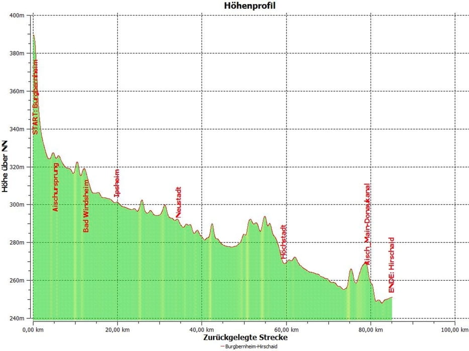
Minimum height 247 m
Maximum height 398 m
More about the tour author
|
|
Berndinho |
Komentarze

Start am Bahnhof Burgbernheim,
Ende am Bahnhof Hirschaid.
Ende am Bahnhof Hirschaid.
GPS tracks
Trackpoints-
GPX / Garmin Map Source (gpx) download
-
TCX / Garmin Training Center® (tcx) download
-
CRS / Garmin Training Center® (crs) download
-
Google Earth (kml) download
-
G7ToWin (g7t) download
-
TTQV (trk) download
-
Overlay (ovl) download
-
Fugawi (txt) download
-
Kompass (DAV) Track (tk) download
-
Karta trasy (pdf) download
-
Original file of the author (gpx) download
More about the tour author
|
|
Berndinho |
Add to my favorites
Remove from my favorites
Edit tags
Open track
My score
Rate