Login

Zapomniałeś swój login?

Cookies have to be accepted!
Your browser's cookie functionality is disabled. Please enable this functionality.

Not a member yet?

Register now
Login

Available for registred users only

Log in to use this feature.

Zapomniałeś swój login?

Cookies have to be accepted!
Your browser's cookie functionality is disabled. Please enable this functionality.

Not a member yet?

Register now
Filter
Kategorie
Advanced filters
  • Długość (km)
  • Wysokość
Zapisz filtr Reset filter

TrackRank

QRCode

Technical data

Długość32,6 km Wysokość207 m Way down206 m Czas trwania01:30 h:m Data05.05.2014
Oceny Author Krajobraz Czynnik zadowolenia Kondycja Technika

Statystyka

87 Widoki Oceny 4 Downloads / Pliki do pobrania Przeciętnie
Rate
  • Karta trasy
  • Dojazd
  • Downloads / Pliki do pobrania

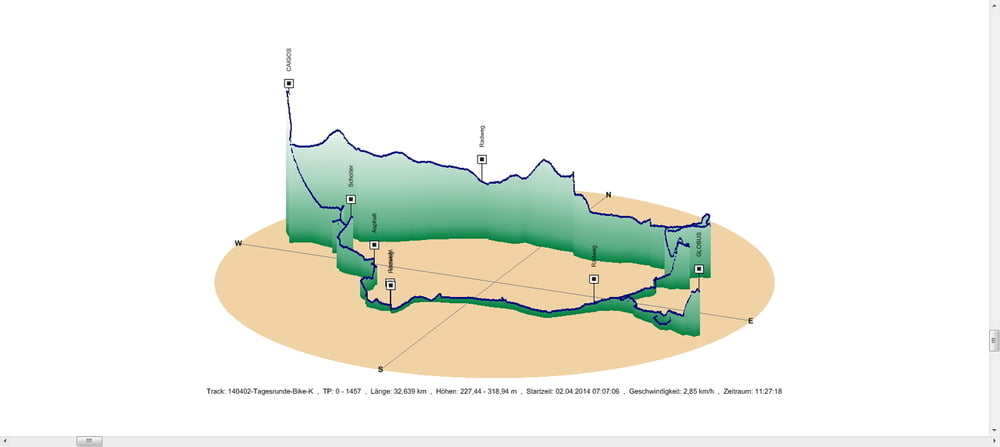
Von Schwarzenbach nach Kirkel nahm ich an diesem Tag eine nicht optimale Wegstrecke. Landschaftlich war sie trotzdem ganz nett.

Der Weg von Kirkel nach Schwarzenbach führte mich durch das Kirkeler Tal nach Lautzkirchen und durch das Bliestal über den Globus in Einöd zum Ausgangspunkt zurück.

Das war eine schöne Variante.


Further information at

https://de.wikipedia.org/wiki/Blies

Galeria trasy

Mapa trasy i profil wysokości

  • Open Street Map
  • Google
Minimum height 227 m Maximum height 319 m Widok szczegółowy

More about the tour author

Pheinz
Member since 2009

Send private message

Komentarze

In Schwarzenbach geht es los.

GPS tracks

Trackpoints
  • GPX / Garmin Map Source (gpx) download
  • TCX / Garmin Training Center® (tcx) download
  • CRS / Garmin Training Center® (crs) download
  • Google Earth (kml) download
  • G7ToWin (g7t) download
  • TTQV (trk) download
  • Overlay (ovl) download
  • Fugawi (txt) download
  • Kompass (DAV) Track (tk) download
  • Karta trasy (pdf) download
  • Original file of the author (gpx) download

More about the tour author

Pheinz
Member since 2009

Send private message
Share track
Add to my favorites
Remove from my favorites
Edit tags
My score
Rate
Trasa: 140402-Tagestour
Rodzaj: Trasy rowerowe
Długość: 32,6 km
Evaluated on:
Czas trwania:
Day(s)
Hour(s)
Minute(s)
Ocena: Krajobraz Czynnik zadowolenia Kondycja Technika