Login

Zapomniałeś swój login?

Cookies have to be accepted!
Your browser's cookie functionality is disabled. Please enable this functionality.

Not a member yet?

Register now
Login

Available for registred users only

Log in to use this feature.

Zapomniałeś swój login?

Cookies have to be accepted!
Your browser's cookie functionality is disabled. Please enable this functionality.

Not a member yet?

Register now
Filter
Kategorie
Advanced filters
  • Długość (km)
  • Wysokość
Zapisz filtr Reset filter

TrackRank

QRCode

Technical data

Długość12,7 km Wysokość283 m Way down387 m Czas trwania03:57 h:m Data10.02.2008
Oceny Author Krajobraz Czynnik zadowolenia Kondycja Technika

Statystyka

726 Widoki Oceny 58 Downloads / Pliki do pobrania Przeciętnie
Rate
  • Karta trasy
  • Dojazd
  • Downloads / Pliki do pobrania
Vom aussichtsreichen Nebelstein immer südwärts und bergab bis ins Tal der in die Nordsee entwässernden Lainsitz.
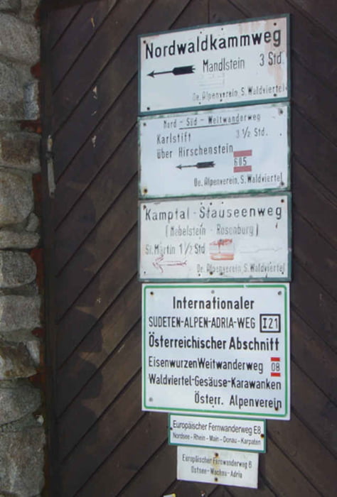
Das letzte Stück durch das Einsiedelbachtal aufwärts nach Karlsstift.

Galeria trasy

Mapa trasy i profil wysokości

  • Open Street Map
  • Google
Minimum height 662 m Maximum height 1017 m Widok szczegółowy

More about the tour author

rail-com

Komentarze

Bus bis St. Martin bei Weitra.
Weiter zum Nebelstein mit Taxi.

GPS tracks

Trackpoints
  • GPX / Garmin Map Source (gpx) download
  • TCX / Garmin Training Center® (tcx) download
  • CRS / Garmin Training Center® (crs) download
  • Google Earth (kml) download
  • G7ToWin (g7t) download
  • TTQV (trk) download
  • Overlay (ovl) download
  • Fugawi (txt) download
  • Kompass (DAV) Track (tk) download
  • Karta trasy (pdf) download

More about the tour author

rail-com

Share track
Add to my favorites
Remove from my favorites
Edit tags
My score
Rate
Trasa: Nord - Süd Weitwanderweg 05: 001 Nebelstein - Karlsstift
Rodzaj: Wędrówki
Długość: 12,7 km
Evaluated on:
Czas trwania:
Day(s)
Hour(s)
Minute(s)
Ocena: Krajobraz Czynnik zadowolenia Kondycja Technika