Login

Zapomniałeś swój login?

Cookies have to be accepted!
Your browser's cookie functionality is disabled. Please enable this functionality.

Not a member yet?

Register now
Login

Available for registred users only

Log in to use this feature.

Zapomniałeś swój login?

Cookies have to be accepted!
Your browser's cookie functionality is disabled. Please enable this functionality.

Not a member yet?

Register now
Filter
Kategorie
Advanced filters
  • Długość (km)
  • Wysokość
Zapisz filtr Reset filter

TrackRank

QRCode

Technical data

Długość4,2 km Wysokość0 m Way down0 m Czas trwania03:00 h:m Data12.02.2008
Oceny Author User Krajobraz Czynnik zadowolenia Kondycja Technika

Statystyka

8575 Widoki 2 Oceny 621 Downloads / Pliki do pobrania 5.00 Przeciętnie
Rate
  • Karta trasy
  • Dojazd
  • Downloads / Pliki do pobrania
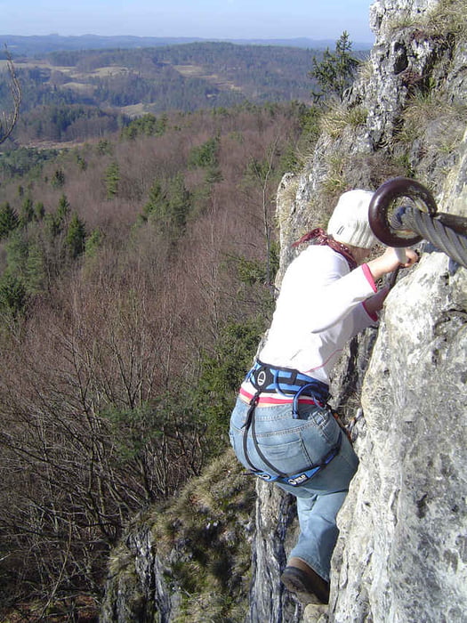
Mehrere steile Wände, durch kurze Wanderwege miteinander verbunden, sind an straff gespannten Stahlseilen zu queren. Die Routenführung ist betont sportlich angelegt, die technischen Schwierigkeiten werden zum Ende der Route hin gesteigert. An einigen Stellen sind bewusst Trittstifte weggelassen - an Fragmenten kleiner speckiger Trittstellen stemmt man sich gegen die Wand, die Armmuskeln werden beim Umschnappen der Karabiner kräftig gefordert.

Galeria trasy

Mapa trasy i profil wysokości

  • Open Street Map
  • Google
Minimum height 99999 m Maximum height 2147483647 m Widok szczegółowy

More about the tour author

Chrisbeechip

Komentarze

ray123456 on 19.03.2009

geniales HGS- video

wer noch nicht am HGS war, aber einen guten Eindruck von dem steig gewinnen möchte, dem empfehle ich folgendes Video: http://www.youtube.com/watch?v=0bEYYLyU8oI
Los gehts in Hirschbach.

GPS tracks

Trackpoints
  • GPX / Garmin Map Source (gpx) download
  • TCX / Garmin Training Center® (tcx) download
  • CRS / Garmin Training Center® (crs) download
  • Google Earth (kml) download
  • G7ToWin (g7t) download
  • TTQV (trk) download
  • Overlay (ovl) download
  • Fugawi (txt) download
  • Kompass (DAV) Track (tk) download
  • Karta trasy (pdf) download
  • Original file of the author (g7t) download

More about the tour author

Chrisbeechip

Share track
Add to my favorites
Remove from my favorites
Edit tags
My score
Rate
Trasa: Höhenglücksteig
Rodzaj: Wspinaczka ściankowa
Długość: 4,2 km
Evaluated on:
Czas trwania:
Day(s)
Hour(s)
Minute(s)
Ocena: Krajobraz Czynnik zadowolenia Kondycja Technika