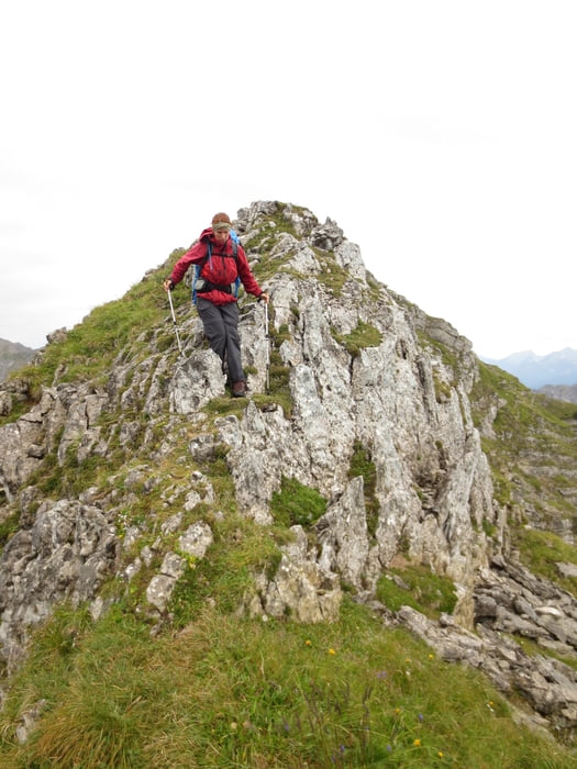
Schöne Tour vom Soiernhaus mit einsamer Gratwanderung von der Gumpenkarspitze auf die Krapfenkarspitze.
Der Weg vom Soiernhaus auf den Sattel Jägersruh ist markiert und in der AV-Karte BY 10 eingezeichnet. Der Weg vom Sattel auf die Gumpenkarspitze ist markiert, aber nicht in dieser Karte verkauft. Bei beiden wegen handelt es sich um alpine Wanderwege die keine besonderen Anforderungen stellen.
Die Gratwanderung ist aber weder markiert noch in der Karte verzeichnet. Man findet lediglich Pfadspuren und an kritischen Stellen auch Steinmandl. Entsprechend stellt der Track hier nur eine mögliche Route entlang des Grates dar. Vor Ort sind Erfahrung und eigenes Beurteilsungsvermögen notwendig. Der Weg ist teilweise etwas ausgesetzt und wartet mit der ein oder anderen Stelle im UIAA-Grad I auf.
Abstieg wie Aufstieg. (alternativ kann man nach Hinterriss weiterwandern, siehe Tour unbekanntes Karwendel)
Further information at
http://www.sektion-hochland.de/soiernhaus/index.htmlGaleria trasy
Mapa trasy i profil wysokości
Komentarze

Zur Anreise auf das Soiernhaus gibt es mehrere Möglichkeiten:
- von Krün über die FIschbachalm
- von Krün über das Feldernkreuz
- vom Parkplatz Seinsalm (Mittenwald) über das Feldernkreuz
- vom Parkplatz Seinsalm (Mittenwald) über die Soiernspitze
- vom Parkplatz Seinsalm (Mittenwald) über die Jägersruh (von hier kann man direkt auf die Gumpenkarspitze starten)
GPS tracks
Trackpoints-
GPX / Garmin Map Source (gpx) download
-
TCX / Garmin Training Center® (tcx) download
-
CRS / Garmin Training Center® (crs) download
-
Google Earth (kml) download
-
G7ToWin (g7t) download
-
TTQV (trk) download
-
Overlay (ovl) download
-
Fugawi (txt) download
-
Kompass (DAV) Track (tk) download
-
Karta trasy (pdf) download
-
Original file of the author (gpx) download


