


Von Schwarzenbach nach Kirkel auf den örtlichen Radwegen die weitgehend im Tal verlaufen.
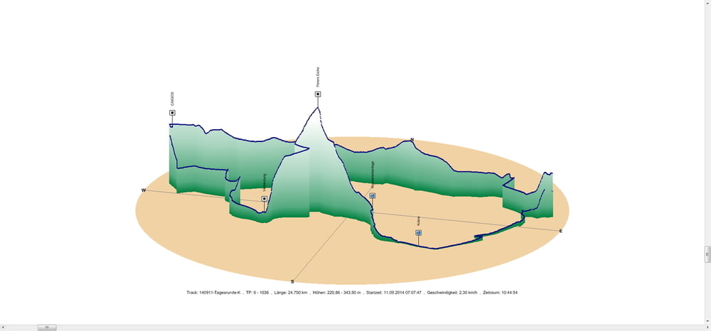
Am Abend rollte ich zuerst durch Kirkel Neuhäusel und dann im Kirkeler Tal bis ich nach dem kleinen Verbindungspfad gleich links den Berg hochfuhr. Die Steigung ist schön moderat und nicht sehr anstrengend. Nur das letzte Stück vor Peters Eiche kommt dann ein wenig steiler daher.
Gleich wieder rechts haltend runter und nach tollen Abfahrtspassagen an der Fischerhütte vorbei zum Wassertretbecken. Gleich darauf durch Bierbach an der Blies und von dort auf dem flachen Radweg zurück nach Schwarzenbach.
Nette Runde wenn das Wetter mitmacht. Ich durfte kurz duschen.
Further information at
https://de.wikipedia.org/wiki/Saarpfalz-KreisGaleria trasy


Mapa trasy i profil wysokości
Minimum height 221 m
Maximum height 344 m
More about the tour author
|
|
Pheinz |
Komentarze

In Schwarzenbach geht es los.
GPS tracks
Trackpoints-
GPX / Garmin Map Source (gpx) download
-
TCX / Garmin Training Center® (tcx) download
-
CRS / Garmin Training Center® (crs) download
-
Google Earth (kml) download
-
G7ToWin (g7t) download
-
TTQV (trk) download
-
Overlay (ovl) download
-
Fugawi (txt) download
-
Kompass (DAV) Track (tk) download
-
Karta trasy (pdf) download
-
Original file of the author (gpx) download
More about the tour author
|
|
Pheinz |
Add to my favorites
Remove from my favorites
Edit tags
Open track
My score
Rate