
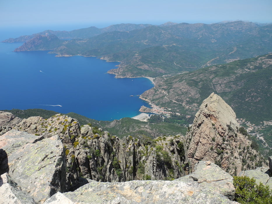

Die Wanderung führt vom Sportplatz Piana auf den Aussichtsberg Capu d'Orto. Zunächst geht es durch Kiefernwälder bis zur Foca d'Orto. Danach kommt der packendste Streckenteil. Für nicht schwindelfreie absolut nicht zu empfehlen und auch mit Kindern würde ich nicht durch die Wand gehen. Es geht durch eine Steile Wand, aber jederzeit auf griffigem Fels recht steil nach oben, bis man dann auf einem Vorgipfel ankommt. Dort schon toller Ausblick auf das Hochgebirge. Die Route ist zwar nur mit Steinmännchen markiert, aber es fällt eigentlich nicht schwer, diese zu erkennen. Der restliche Weg bis zum Hauptgipfel ist nicht mehr so anstrengend. Oben angekommen hat man das "Korsika-Feeling" - Meer und Hochgebirge zusammen. Der Abstieg ist relativ einfach. Die Tour ist auch im Rother Wanderführer beschrieben.
Galeria trasy

Mapa trasy i profil wysokości
Minimum height 483 m
Maximum height 1298 m
More about the tour author

|
jpw |
Komentarze

Von Piana kommend noch vor der Calanche rechts zum Sportplatz abbiegen (Schild). Dort ist ein grosser Parkplatz.
GPS tracks
Trackpoints-
GPX / Garmin Map Source (gpx) download
-
TCX / Garmin Training Center® (tcx) download
-
CRS / Garmin Training Center® (crs) download
-
Google Earth (kml) download
-
G7ToWin (g7t) download
-
TTQV (trk) download
-
Overlay (ovl) download
-
Fugawi (txt) download
-
Kompass (DAV) Track (tk) download
-
Karta trasy (pdf) download
-
Original file of the author (gpx) download
More about the tour author
|
|
jpw |
Add to my favorites
Remove from my favorites
Edit tags
Open track
My score
Rate