Login

Zapomniałeś swój login?

Cookies have to be accepted!
Your browser's cookie functionality is disabled. Please enable this functionality.

Not a member yet?

Register now
Login

Available for registred users only

Log in to use this feature.

Zapomniałeś swój login?

Cookies have to be accepted!
Your browser's cookie functionality is disabled. Please enable this functionality.

Not a member yet?

Register now
Filter
Kategorie
Advanced filters
  • Długość (km)
  • Wysokość
Zapisz filtr Reset filter

TrackRank

QRCode

Technical data

Długość14,4 km Wysokość440 m Way down441 m Czas trwania04:20 h:m Data29.10.2015
Oceny Author Krajobraz Czynnik zadowolenia Kondycja Technika

Statystyka

662 Widoki Oceny 50 Downloads / Pliki do pobrania Przeciętnie
Rate
  • Karta trasy
  • Dojazd
  • Downloads / Pliki do pobrania

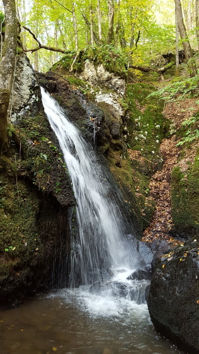
Wanderung von Villapourcon über Wald- und Feldwege zur wilden Schlucht mit Wasserfall.

Der Zugang zu der Schlucht ist am Feldweg ausgeschildert. Da er unweit eines Ortes und einer Straße ist, begegnet man hier am Wochenende of Spatziergängern.


Further information at

http://tourisme.parcdumorvan.org/un-kilometre-a-pied_fr_04_t56.html

Galeria trasy

Mapa trasy i profil wysokości

  • Open Street Map
  • Google
Minimum height 413 m Maximum height 675 m Widok szczegółowy

More about the tour author

wickyg
Member since 2010

Send private message

Komentarze

Auf N81 von Autun kommend, Abzweig rechts auf D3 oder später D61, die dann die D3 kreutzt, der man links nach Villapourcon folgt. Parken in Ortsmitte.

GPS tracks

Trackpoints
  • GPX / Garmin Map Source (gpx) download
  • TCX / Garmin Training Center® (tcx) download
  • CRS / Garmin Training Center® (crs) download
  • Google Earth (kml) download
  • G7ToWin (g7t) download
  • TTQV (trk) download
  • Overlay (ovl) download
  • Fugawi (txt) download
  • Kompass (DAV) Track (tk) download
  • Karta trasy (pdf) download
  • Original file of the author (gpx) download

More about the tour author

wickyg
Member since 2010

Send private message
Share track
Add to my favorites
Remove from my favorites
Edit tags
My score
Rate
Trasa: La Cascade de Dragne
Rodzaj: Wędrówki
Długość: 14,4 km
Evaluated on:
Czas trwania:
Day(s)
Hour(s)
Minute(s)
Ocena: Krajobraz Czynnik zadowolenia Kondycja Technika