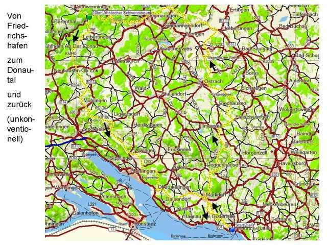
Zugegeben, man kann schneller und direkter zum Donautal fahren. Aber das macht wahrscheinlich den Reiz dieser Tour aus. Man fährt über kleinste Kreisstraßen über Dörfer und ländliche Gebiete. Ist sicher eine unkonventionelle Art, den Bodensee mit dem beliebten Donautal zu verbinden. Wer Zeit hat und auch mal die Umgebung anschauen möchte, dem ist diese Tour zu empfehlen. Höhepunkt ist natürlich das Donautal mit seinen tollen Felsen. Der Abstecher nach Schwenningen nimmt etwa 10km in Anspruch. Dieser kann natürlich weggelassen werden. Trotzdem ist der Abstecher recht nett, denn man fährt nochmals an Felsen vorbei und durch ein shönes Felsentor. Der Weg nach Hause ist wie bei der Anfahrt eine beschauliche Strecke durch kleinste Dörfer und über kleinste Nebenstrecken. Schöne Halbtages-Rundtour.
Mapa trasy i profil wysokości
Minimum height 411 m
Maximum height 855 m
Komentarze
Die Tour startet und endet in Friedrichshafen. Markdorf oder andere Städte entlang des Weges eignen sich aber auch gut als Startpunkt.
GPS tracks
Trackpoints-
GPX / Garmin Map Source (gpx) download
-
TCX / Garmin Training Center® (tcx) download
-
CRS / Garmin Training Center® (crs) download
-
Google Earth (kml) download
-
G7ToWin (g7t) download
-
TTQV (trk) download
-
Overlay (ovl) download
-
Fugawi (txt) download
-
Kompass (DAV) Track (tk) download
-
Karta trasy (pdf) download
-
Original file of the author (gpx) download
Add to my favorites
Remove from my favorites
Edit tags
Open track
My score
Rate


genial unkonventionell