


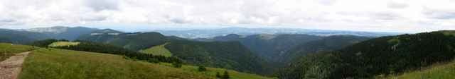
Nette Wanderung (Rundtour) mit vielen schoenen Aussichten in den Schwarzwald (Blick u.a. auf Feldberg, Schauinsland, Belchen, ...). Am Anfang und am Ende etwas steil, sonst einfach. Ca 3:45 eine Gehzeit, mit Pausen macht das dann ca 4:30-5:00.
Trackfile copyright under Creative Commons (by attribution, share alike). See: http://creativecommons.org/licenses/by-sa/2.5/
Karte: Freiburg Rad- und Wanderwege WR50, 1:50000, Landesvermessungsamt BW.
Trackfile copyright under Creative Commons (by attribution, share alike). See: http://creativecommons.org/licenses/by-sa/2.5/
Karte: Freiburg Rad- und Wanderwege WR50, 1:50000, Landesvermessungsamt BW.
Galeria trasy
Mapa trasy i profil wysokości
Minimum height 716 m
Maximum height 1498 m
More about the tour author

|
Komentarze

Rundtour.
Kostenloses Parken in St. Wilhelm ausgeschildert.
Anfahrt von Freiburg aus: Kirchzarten-> Oberried -> St. Wilhelm.
Kostenloses Parken in St. Wilhelm ausgeschildert.
Anfahrt von Freiburg aus: Kirchzarten-> Oberried -> St. Wilhelm.
GPS tracks
Trackpoints-
GPX / Garmin Map Source (gpx) download
-
TCX / Garmin Training Center® (tcx) download
-
CRS / Garmin Training Center® (crs) download
-
Google Earth (kml) download
-
G7ToWin (g7t) download
-
TTQV (trk) download
-
Overlay (ovl) download
-
Fugawi (txt) download
-
Kompass (DAV) Track (tk) download
-
Karta trasy (pdf) download
-
Original file of the author (g7t) download
More about the tour author
|
|
Add to my favorites
Remove from my favorites
Edit tags
Open track
My score
Rate