
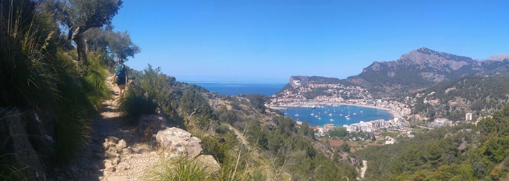

Liebliche Rundtour von Port de Soller hinauf zum Refugium Muleta durch Olivenbaumplantagen und Kiefernwälder. Am Refugium schweift der Blick aufs weite, weite Meer, während man einen Kaffee schlürft. Danach Abstieg nach Port de Soller auf Straße, entlang der Steilküste und mondäner Villen. Hier und immer wieder vorher beeindruckende Ausblicke auf die Bucht . Einkehrmöglichkeiten in einem Agroturismo auf einem Drittel der Strecke und im Refugium (dort nur Getränke). Für mehr Eindrücke siehe mein Google Fotos Link unten.
Baby-Kinder-Hike: Prima begehbar mit Kraxe. Kurz vorm Refugium muss man einige Zeit etwas acht geben wegen der vielen Steine. Auf dem Weg immer wieder Esel, Schafe und Ziegen zu bestaunen. Tipp: Im Restaurant Es Reco am westlichen Ende der Bucht von Port de Soller (Tourende) isst man zwar nicht herausragend, dafür aber an Tischen am oder auf dem Strand und die Kinder können im Sand spielen, das Restaurant hat auch Spielzeug - easy!
Further information at
https://photos.app.goo.gl/efr1opVV1BG7q3xj6Galeria trasy


Mapa trasy i profil wysokości
Minimum height -3 m
Maximum height 194 m
More about the tour author
|
|
mackator |
Komentarze

Port de Soller
GPS tracks
Trackpoints-
GPX / Garmin Map Source (gpx) download
-
TCX / Garmin Training Center® (tcx) download
-
CRS / Garmin Training Center® (crs) download
-
Google Earth (kml) download
-
G7ToWin (g7t) download
-
TTQV (trk) download
-
Overlay (ovl) download
-
Fugawi (txt) download
-
Kompass (DAV) Track (tk) download
-
Karta trasy (pdf) download
-
Original file of the author (gpx) download
More about the tour author
|
|
mackator |
Add to my favorites
Remove from my favorites
Edit tags
Open track
My score
Rate