Login

Zapomniałeś swój login?

Cookies have to be accepted!
Your browser's cookie functionality is disabled. Please enable this functionality.

Not a member yet?

Register now
Login

Available for registred users only

Log in to use this feature.

Zapomniałeś swój login?

Cookies have to be accepted!
Your browser's cookie functionality is disabled. Please enable this functionality.

Not a member yet?

Register now
Filter
Kategorie
Advanced filters
  • Długość (km)
  • Wysokość
Zapisz filtr Reset filter

TrackRank

QRCode

Technical data

Długość27,2 km Wysokość598 m Way down629 m Czas trwania02:40 h:m Data05.04.2020
Oceny Author Krajobraz Czynnik zadowolenia Kondycja Technika

Statystyka

123 Widoki Oceny 13 Downloads / Pliki do pobrania Przeciętnie
Rate
  • Karta trasy
  • Dojazd
  • Downloads / Pliki do pobrania

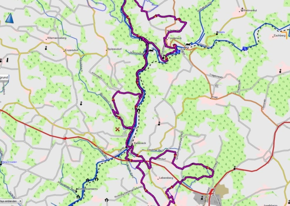
Sehr schöne MTB Tour durch das Ilztal.

Ein steiges auf und ab mit immer wechselnden ausblicken auf das Ilztal.

Teils auf wenig befahrenen Strassen, Feldwegen und ein paar netten Trails.

Nur mit MTB zu fahren.

Einkehrmöglichkeit in der Schrottenbaummühle.

Startpunkt wie so oft in Kalteneck am Bahnhof

Viel Spass mein nachfahren

Mapa trasy i profil wysokości

  • Open Street Map
  • Google
Minimum height 335 m Maximum height 521 m Widok szczegółowy

More about the tour author

franz1962
Member since 2011

Send private message

Komentarze

GPS tracks

Trackpoints
  • GPX / Garmin Map Source (gpx) download
  • TCX / Garmin Training Center® (tcx) download
  • CRS / Garmin Training Center® (crs) download
  • Google Earth (kml) download
  • G7ToWin (g7t) download
  • TTQV (trk) download
  • Overlay (ovl) download
  • Fugawi (txt) download
  • Kompass (DAV) Track (tk) download
  • Karta trasy (pdf) download
  • Original file of the author (gpx) download

More about the tour author

franz1962
Member since 2011

Send private message
Share track
Add to my favorites
Remove from my favorites
Edit tags
My score
Rate
Trasa: Hutthurm_Auretzdorf_Allmunzen_Fürsteneck_Anzereuth_Schrottenbaummühle_zurück
Rodzaj: Rower górski (MTB)
Długość: 27,2 km
Evaluated on:
Czas trwania:
Day(s)
Hour(s)
Minute(s)
Ocena: Krajobraz Czynnik zadowolenia Kondycja Technika