


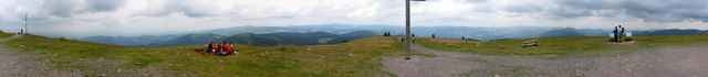
Nette Rundtour von Mulden uber Breitnau auf das Belchen. Dort geniale Aussicht auf die Berge des Schwazwaldes. Dauer etwa 5h ohne Pause, ca 6h mit.
Trackfile copyright under Creative Commons (by attribution, share alike). See: http://creativecommons.org/licenses/by-sa/2.5/
Karte: Freiburg Rad- und Wanderwege WR50, 1:50000, Landesvermessungsamt BW.
Trackfile copyright under Creative Commons (by attribution, share alike). See: http://creativecommons.org/licenses/by-sa/2.5/
Karte: Freiburg Rad- und Wanderwege WR50, 1:50000, Landesvermessungsamt BW.
Galeria trasy
Mapa trasy i profil wysokości
Minimum height 544 m
Maximum height 1431 m
More about the tour author

|
Komentarze

Besucherbergwerk bei Mulden/Muenstertal (suedlich von Freiburg) dort kostenloser Parkplatz.
GPS tracks
Trackpoints-
GPX / Garmin Map Source (gpx) download
-
TCX / Garmin Training Center® (tcx) download
-
CRS / Garmin Training Center® (crs) download
-
Google Earth (kml) download
-
G7ToWin (g7t) download
-
TTQV (trk) download
-
Overlay (ovl) download
-
Fugawi (txt) download
-
Kompass (DAV) Track (tk) download
-
Karta trasy (pdf) download
-
Original file of the author (g7t) download
More about the tour author
|
|
Add to my favorites
Remove from my favorites
Edit tags
Open track
My score
Rate