

Ausgangs- u. Zielpunkt ist die Klinik Berlin der BfA.
Die Tour führt über asphaltierte Wege an der Nordseite des Sollberges entlang. Man befindet sich fast immer in Sichtweite der Klinik.
Die Tour führt über asphaltierte Wege an der Nordseite des Sollberges entlang. Man befindet sich fast immer in Sichtweite der Klinik.
Mapa trasy i profil wysokości
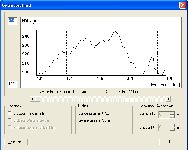
Minimum height 206 m
Maximum height 261 m
More about the tour author
|
|
KaufensH |
Komentarze

Von der A44
Bei der Anschlussstelle Diemelstadt (64) abfahren auf die B252 und in nördlicher Richtung auf der B252 Richtung Scherfede.
Geradeaus weiter auf der L828 Richtung Willebadessen, Neuenheerse.
Hier rechts abbiegen auf die L954 und weiter nach Bad Driburg.
Rechts einbiegen auf die B64, nach etwa 1,5 km links auf die Brakeler Straße abbiegen.
Nach einem weiteren km rechts abbiegen in die Brunnenstrasse (K18) wo nach weiteren 500 m ziemlich am Ortsende der Startpunkt der Tour erreicht wird.
GPS tracks
Trackpoints-
GPX / Garmin Map Source (gpx) download
-
TCX / Garmin Training Center® (tcx) download
-
CRS / Garmin Training Center® (crs) download
-
Google Earth (kml) download
-
G7ToWin (g7t) download
-
TTQV (trk) download
-
Overlay (ovl) download
-
Fugawi (txt) download
-
Kompass (DAV) Track (tk) download
-
Karta trasy (pdf) download
More about the tour author
|
|
KaufensH |
Add to my favorites
Remove from my favorites
Edit tags
Open track
My score
Rate