Login

Zapomniałeś swój login?

Cookies have to be accepted!
Your browser's cookie functionality is disabled. Please enable this functionality.

Not a member yet?

Register now
Login

Available for registred users only

Log in to use this feature.

Zapomniałeś swój login?

Cookies have to be accepted!
Your browser's cookie functionality is disabled. Please enable this functionality.

Not a member yet?

Register now
Filter
Kategorie
Advanced filters
  • Długość (km)
  • Wysokość
Zapisz filtr Reset filter

TrackRank

QRCode

Technical data

Długość8,2 km Wysokość438 m Way down438 m Czas trwania03:00 h:m Data20.08.2023
Oceny Author Krajobraz Czynnik zadowolenia Kondycja Technika

Statystyka

174 Widoki Oceny 1 Download Przeciętnie
Rate
  • Karta trasy
  • Dojazd
  • Downloads / Pliki do pobrania

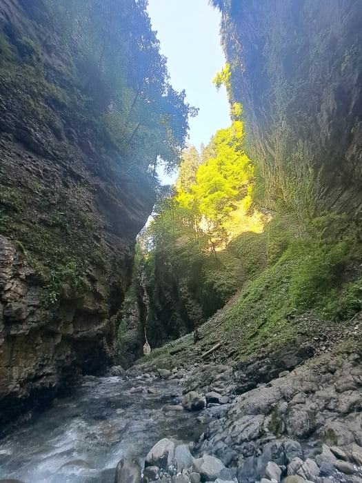
Sehr beeindruckende Schlucht.

Trittsicherheit ist Pflicht. 

In der Schlucht ist der GPS-Track etwas zick zack. Das stimmt so nicht, der Empfang war nur schlecht. Der Weg ist aber eindeutig und nicht zu verfehlen.

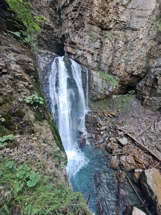
Wer es gerne frisch mag pack die Badesachen ein. Es gibt "Badestellen".

Insbesondere im Hochsommer eine wilkommene Flucht vor der Hitze. 

Galeria trasy

Mapa trasy i profil wysokości

  • Open Street Map
  • Google
Minimum height 672 m Maximum height 960 m Widok szczegółowy

More about the tour author

Christi0012
Member since 2005

Send private message

Komentarze

Das Laternsertal rein und am Beginn des Tracks am offentlichen Parkplatz parken.

GPS tracks

Trackpoints
  • GPX / Garmin Map Source (gpx) download
  • TCX / Garmin Training Center® (tcx) download
  • CRS / Garmin Training Center® (crs) download
  • Google Earth (kml) download
  • G7ToWin (g7t) download
  • TTQV (trk) download
  • Overlay (ovl) download
  • Fugawi (txt) download
  • Kompass (DAV) Track (tk) download
  • Karta trasy (pdf) download
  • Original file of the author (gpx) download

More about the tour author

Christi0012
Member since 2005

Send private message
Share track
Add to my favorites
Remove from my favorites
Edit tags
My score
Rate
Trasa: Üble Schlucht ab Laterns
Rodzaj: Wędrówki
Długość: 8,2 km
Evaluated on:
Czas trwania:
Day(s)
Hour(s)
Minute(s)
Ocena: Krajobraz Czynnik zadowolenia Kondycja Technika