Login

Zapomniałeś swój login?

Cookies have to be accepted!
Your browser's cookie functionality is disabled. Please enable this functionality.

Not a member yet?

Register now
Login

Available for registred users only

Log in to use this feature.

Zapomniałeś swój login?

Cookies have to be accepted!
Your browser's cookie functionality is disabled. Please enable this functionality.

Not a member yet?

Register now
Filter
Kategorie
Advanced filters
  • Długość (km)
  • Wysokość
Zapisz filtr Reset filter

TrackRank

QRCode

Technical data

Długość54,0 km Wysokość1262 m Way down1238 m Czas trwania00:00 h:m Data28.11.2023
Oceny Author Krajobraz Czynnik zadowolenia Kondycja Technika

Statystyka

227 Widoki Oceny 4 Downloads / Pliki do pobrania Przeciętnie
Rate
  • Karta trasy
  • Dojazd
  • Downloads / Pliki do pobrania

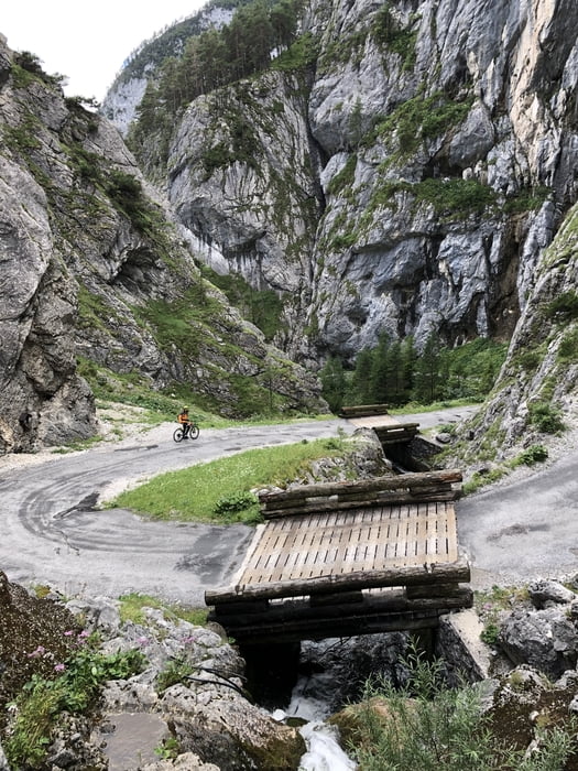
Tag 4 der Dachsteinumrundung. Tag 3 (Gosau-Bad Aussee) fuhren wir auf kürzester Strecke in strömenden Regen. Ab km 11 weiter der Forststraße folgen und nicht dem Track. Wir hatten uns durch ein falsch aufgestelltes Dachsteinrunde Schild in die Irre leiten lassen. Die Abfahrt durch die "Hölle" ist zwar auf Asphalt - aber trotzdem spektakulär!


Galeria trasy

Mapa trasy i profil wysokości

  • Open Street Map
  • Google
Minimum height 652 m Maximum height 1470 m Widok szczegółowy

More about the tour author

ETTMAYER
Member since 2007

Send private message

Komentarze

GPS tracks

Trackpoints
  • GPX / Garmin Map Source (gpx) download
  • TCX / Garmin Training Center® (tcx) download
  • CRS / Garmin Training Center® (crs) download
  • Google Earth (kml) download
  • G7ToWin (g7t) download
  • TTQV (trk) download
  • Overlay (ovl) download
  • Fugawi (txt) download
  • Kompass (DAV) Track (tk) download
  • Karta trasy (pdf) download
  • Original file of the author (gpx) download

More about the tour author

ETTMAYER
Member since 2007

Send private message
Share track
Add to my favorites
Remove from my favorites
Edit tags
My score
Rate
Trasa: Dachsteinrunde: Bad Aussee -Gröbming
Rodzaj: Rower górski (MTB)
Długość: 54,0 km
Evaluated on:
Czas trwania:
Day(s)
Hour(s)
Minute(s)
Ocena: Krajobraz Czynnik zadowolenia Kondycja Technika