Login

Zapomniałeś swój login?

Cookies have to be accepted!
Your browser's cookie functionality is disabled. Please enable this functionality.

Not a member yet?

Register now
Login

Available for registred users only

Log in to use this feature.

Zapomniałeś swój login?

Cookies have to be accepted!
Your browser's cookie functionality is disabled. Please enable this functionality.

Not a member yet?

Register now
Filter
Kategorie
Advanced filters
  • Długość (km)
  • Wysokość
Zapisz filtr Reset filter

TrackRank

QRCode

Technical data

Długość47,4 km Wysokość701 m Way down713 m Czas trwania05:00 h:m Data23.07.2008
Oceny Author Krajobraz Czynnik zadowolenia Kondycja Technika

Statystyka

1979 Widoki Oceny 620 Downloads / Pliki do pobrania Przeciętnie
Rate
  • Karta trasy
  • Dojazd
  • Downloads / Pliki do pobrania
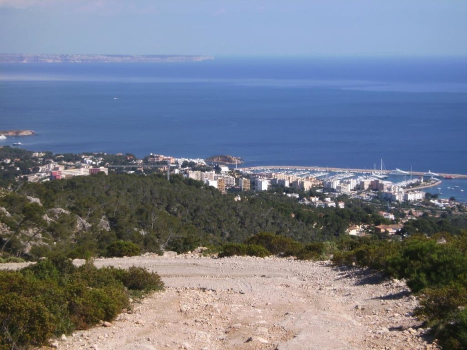
Von Santa Ponca zunächst auf bezeichneten Radrouten über Calvia Richtung Establiments, dann Abzweig Richtung Palma und bei einer Schranke kurz vor dem Coll de Sa Creu ins Gelände. Nur bis hierher Teerstraßen. Nun auf Schotter abwechslungsreich hoch über dem Meer durch die Serra de na Burguesa, nur kurze Steilstufen, bis die Straße Richtung Palma Nova abwärts führt. Noch vor der Abfahrt könnte bis zum Aussichtsturm bzw. Fernsehsehnder weitergefahren werden, 15 Minuten zusätzliche Auffahrt. Rückfahrt auf Radwege über Son Ferrer und El Toro nach Santa Ponca. Varianten sind möglich

Galeria trasy

Mapa trasy i profil wysokości

  • Open Street Map
  • Google
Minimum height 2 m Maximum height 480 m Widok szczegółowy

Komentarze

Matt_ho on 06.04.2012

Schöne Tour

Wir sind die Tour im April 2012 gefahren. Der Anstieg ist größtenteils eine wenig befahrene Straße, das letzte steilere Stück dann Schotter. Die anschließende Abfahrt ist sehr spaßig. Die Tour ist ohne besondere Fahrtechnik komplett fahrbar. Sehr zu empfehlen.
Von Salzburg mit Airberlin nach Palma und mit Taxi zur FeWo in Santa Ponca. Jeder andere Ferienort an der Westküste Mallorcas ist als Ausgangspunkt geeignet.

GPS tracks

Trackpoints
  • GPX / Garmin Map Source (gpx) download
  • TCX / Garmin Training Center® (tcx) download
  • CRS / Garmin Training Center® (crs) download
  • Google Earth (kml) download
  • G7ToWin (g7t) download
  • TTQV (trk) download
  • Overlay (ovl) download
  • Fugawi (txt) download
  • Kompass (DAV) Track (tk) download
  • Karta trasy (pdf) download
  • Original file of the author (gpx) download
Share track
Add to my favorites
Remove from my favorites
Edit tags
My score
Rate
Trasa: Gipfeltour über Palma
Rodzaj: Rower górski (MTB)
Długość: 47,4 km
Evaluated on:
Czas trwania:
Day(s)
Hour(s)
Minute(s)
Ocena: Krajobraz Czynnik zadowolenia Kondycja Technika