Login

Zapomniałeś swój login?

Cookies have to be accepted!
Your browser's cookie functionality is disabled. Please enable this functionality.

Not a member yet?

Register now
Login

Available for registred users only

Log in to use this feature.

Zapomniałeś swój login?

Cookies have to be accepted!
Your browser's cookie functionality is disabled. Please enable this functionality.

Not a member yet?

Register now
Filter
Kategorie
Advanced filters
  • Długość (km)
  • Wysokość
Zapisz filtr Reset filter

TrackRank

QRCode

Technical data

Długość8,0 km Wysokość799 m Way down16 m Czas trwania02:00 h:m Data25.08.2008
Oceny Author Krajobraz Czynnik zadowolenia Kondycja Technika

Statystyka

629 Widoki Oceny 54 Downloads / Pliki do pobrania Przeciętnie
Rate
  • Karta trasy
  • Dojazd
  • Downloads / Pliki do pobrania

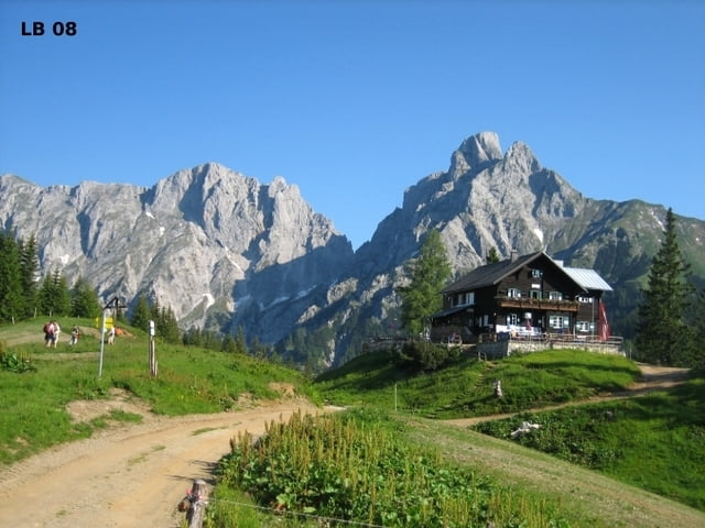
Eine sehr schattige Wanderung auf die Mödlingerhütte, da sie bis auf die letzten 500m durch den Wald führt. Auf dem Weg nach oben hat man nicht viele Aussichtspunkte. Dafür ist aber die Aussicht oben umso schöner. Von unten bis oben führt diese Wanderung auf einem breiten Forstweg, denn leider auch Autos über eine Maut nutzen können.


Weitere Infos und Fotos zur Wanderung auf die Mödlingerhütte findest du auf

biketours4you.at


Mapa trasy i profil wysokości

  • Open Street Map
  • Google
Minimum height 732 m Maximum height 1527 m Widok szczegółowy

More about the tour author

Trek1400d
Member since 2008

Send private message

Komentarze

GPS tracks

Trackpoints
  • GPX / Garmin Map Source (gpx) download
  • TCX / Garmin Training Center® (tcx) download
  • CRS / Garmin Training Center® (crs) download
  • Google Earth (kml) download
  • G7ToWin (g7t) download
  • TTQV (trk) download
  • Overlay (ovl) download
  • Fugawi (txt) download
  • Kompass (DAV) Track (tk) download
  • Karta trasy (pdf) download
  • Original file of the author (gpx) download

More about the tour author

Trek1400d
Member since 2008

Send private message
Share track
Add to my favorites
Remove from my favorites
Edit tags
My score
Rate
Trasa: Mödlingerhütte von Gaishorn am See
Rodzaj: Wędrówki
Długość: 8,0 km
Evaluated on:
Czas trwania:
Day(s)
Hour(s)
Minute(s)
Ocena: Krajobraz Czynnik zadowolenia Kondycja Technika