Login

Zapomniałeś swój login?

Cookies have to be accepted!
Your browser's cookie functionality is disabled. Please enable this functionality.

Not a member yet?

Register now
Login

Available for registred users only

Log in to use this feature.

Zapomniałeś swój login?

Cookies have to be accepted!
Your browser's cookie functionality is disabled. Please enable this functionality.

Not a member yet?

Register now
Filter
Kategorie
Advanced filters
  • Długość (km)
  • Wysokość
Zapisz filtr Reset filter

TrackRank

QRCode

Technical data

Długość32,2 km Wysokość495 m Way down521 m Czas trwania02:10 h:m Data05.11.2008
Oceny Author Krajobraz Czynnik zadowolenia Kondycja Technika

Statystyka

445 Widoki Oceny 95 Downloads / Pliki do pobrania Przeciętnie
Rate
  • Karta trasy
  • Dojazd
  • Downloads / Pliki do pobrania

Technische einfache Rundtour von Eibelstadt über die Mainhangkante nach Frickenhausen. Von dort über die Kapellensteige durch einige Wälder nach Kaltensondheim und zurück.

Kann auch bei schlechten Wetter gut gefahren werden.


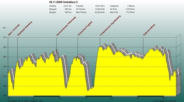
Mapa trasy i profil wysokości

  • Open Street Map
  • Google
Minimum height 184 m Maximum height 300 m Widok szczegółowy

More about the tour author

ramtmann
Member since 2008

Send private message

Komentarze

Eibelstadt

GPS tracks

Trackpoints
  • GPX / Garmin Map Source (gpx) download
  • TCX / Garmin Training Center® (tcx) download
  • CRS / Garmin Training Center® (crs) download
  • Google Earth (kml) download
  • G7ToWin (g7t) download
  • TTQV (trk) download
  • Overlay (ovl) download
  • Fugawi (txt) download
  • Kompass (DAV) Track (tk) download
  • Karta trasy (pdf) download
  • Original file of the author (gpx) download

More about the tour author

ramtmann
Member since 2008

Send private message
Share track
Add to my favorites
Remove from my favorites
Edit tags
My score
Rate
Trasa: Herbsttour 2
Rodzaj: Rower górski (MTB)
Długość: 32,2 km
Evaluated on:
Czas trwania:
Day(s)
Hour(s)
Minute(s)
Ocena: Krajobraz Czynnik zadowolenia Kondycja Technika