Westalpentour: Tour du Mont Cenis
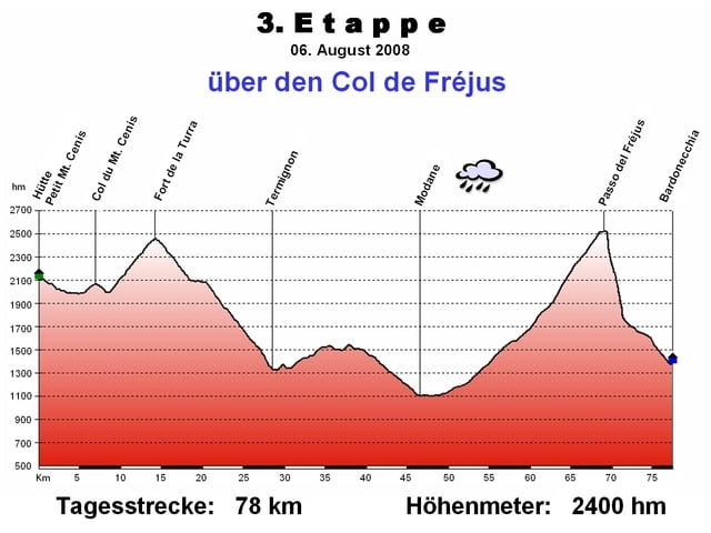
3. Etappe: über den Col de Fréjus
Start: Berghütte Petit Mont Cenis
Ziel: Bardonecchia
Übernachtungsempfehlung:
Berghütte: Petit Mont Cenis
Bardonecchia: Hotel Europa
nächste Etappe siehe „Passo della Mulattiera“ 4. Etappe
Galeria trasy
Mapa trasy i profil wysokości
Minimum height 1077 m
Maximum height 2541 m
Komentarze
GPS tracks
Trackpoints-
GPX / Garmin Map Source (gpx) download
-
TCX / Garmin Training Center® (tcx) download
-
CRS / Garmin Training Center® (crs) download
-
Google Earth (kml) download
-
G7ToWin (g7t) download
-
TTQV (trk) download
-
Overlay (ovl) download
-
Fugawi (txt) download
-
Kompass (DAV) Track (tk) download
-
Karta trasy (pdf) download
-
Original file of the author (gpx) download
Add to my favorites
Remove from my favorites
Edit tags
Open track
My score
Rate


Alternativvariante
In Bardonecchia fanden wir eine sehr nette Untekunft. Der Hausherr war selbst MTBer und gab uns ein paar Tipps: Wirklich empfehelenswert ist die Alternative nicht über den Col de Frejus - wie im Buch von Achim Zahn und in dieser Tour beschrieben - nach Bardonecchia zu fahren sondern über den etwas weiter westlich gelegeneren, exakt gleich hohen "Col der Roue". Wenngleich die letzten 150hm vor dem Sattel nur schiebend zu bewältigen sind, so ist die Abafhart grandios. Alles zu fahren, zu Beginn auf Single-Trails, dann auf Güterwegen, einmal auch durch einen Tunnel. Ca. 0,5km vor Bardonecchia gelangt man dann auf die Asphaltstraße.