Login

Zapomniałeś swój login?

Cookies have to be accepted!
Your browser's cookie functionality is disabled. Please enable this functionality.

Not a member yet?

Register now
Login

Available for registred users only

Log in to use this feature.

Zapomniałeś swój login?

Cookies have to be accepted!
Your browser's cookie functionality is disabled. Please enable this functionality.

Not a member yet?

Register now
Filter
Kategorie
Advanced filters
  • Długość (km)
  • Wysokość
Zapisz filtr Reset filter

TrackRank

QRCode

Technical data

Długość69,9 km Wysokość457 m Way down456 m Czas trwania02:30 h:m Data15.03.2009
Oceny Author Krajobraz Czynnik zadowolenia Kondycja Technika

Statystyka

506 Widoki Oceny 56 Downloads / Pliki do pobrania Przeciętnie
Rate
  • Karta trasy
  • Dojazd
  • Downloads / Pliki do pobrania

Sehr schöne Tour durch den Kraichgau. Anfahrt von Neulußheim nach Malsch und von dort aus geht los. Ein ständiges Auf und Ab.

Zwischendorf gibt es auch einige Besenwirtschaften die mit geringen Preisen locken

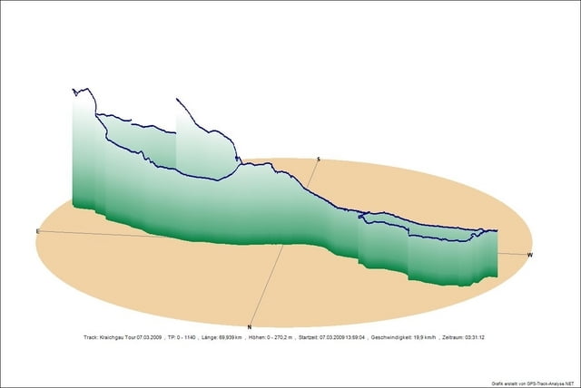
Mapa trasy i profil wysokości

  • Open Street Map
  • Google
Minimum height 99 m Maximum height 270 m Widok szczegółowy

More about the tour author

Bergdoktor
Member since 2009

Send private message

Komentarze

GPS tracks

Trackpoints
  • GPX / Garmin Map Source (gpx) download
  • TCX / Garmin Training Center® (tcx) download
  • CRS / Garmin Training Center® (crs) download
  • Google Earth (kml) download
  • G7ToWin (g7t) download
  • TTQV (trk) download
  • Overlay (ovl) download
  • Fugawi (txt) download
  • Kompass (DAV) Track (tk) download
  • Karta trasy (pdf) download
  • Original file of the author (gpx) download

More about the tour author

Bergdoktor
Member since 2009

Send private message
Share track
Add to my favorites
Remove from my favorites
Edit tags
My score
Rate
Trasa: Kraichgau
Rodzaj: Rower szosowy
Długość: 69,9 km
Evaluated on:
Czas trwania:
Day(s)
Hour(s)
Minute(s)
Ocena: Krajobraz Czynnik zadowolenia Kondycja Technika