
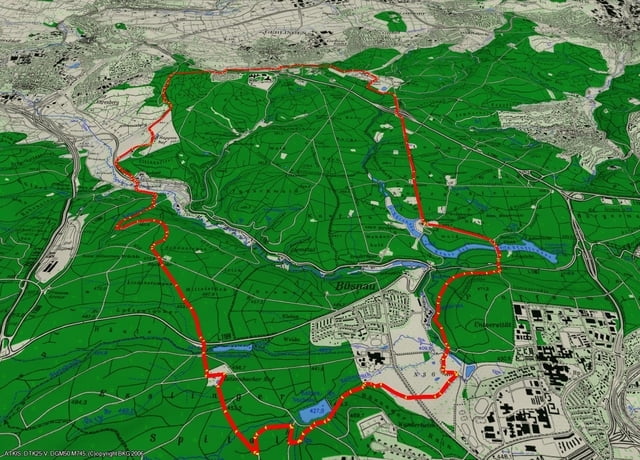

... und schon wieder vergessen das am Sonntag beim Bärenschlössle ganz Stuttgart unterwegs ist. Daher führt diese Laufrund gleich vom Parkplatz am Bärenschlössle Richtung KatzenbacherHof ... obwohl auch hier anscheinend alle Väter und Mütter mit ihren liebsten Kleinen unterwegs sind ... vom Katzenbacherhof geht es nun vorbei an der Blutbuche zum Biker Treffpunkt Glemseck. Bei schönen Wetter, wie heute, sind dort einige wirklch hübsche Maschinen zu bestaunen. Da Glemseck leider im Tal liegt geht es nun einen Anstieg hoch zum Rappenhof. Vom Rappenhof geht es Richtung Schillerhöhe und dann rüber zum Solitude ... heute das erste mal ohne Schnee ... von dort geht es wieder zum Ausgangspunkt, vorbei am Bärenschlössle, zurück ... 20,1 km waren es ... schade es fehlt nur 1km zur HM Distanz ;)
Further information at
http://jog4fun.blogspot.com/Mapa trasy i profil wysokości
Minimum height 377 m
Maximum height 510 m
More about the tour author
|
|
happyend |
Komentarze

Schattenrind - Parkplatz an der Landstrasse ... bei schönen Wetter ist es aber schwer einen solchen zu finden.
GPS tracks
Trackpoints-
GPX / Garmin Map Source (gpx) download
-
TCX / Garmin Training Center® (tcx) download
-
CRS / Garmin Training Center® (crs) download
-
Google Earth (kml) download
-
G7ToWin (g7t) download
-
TTQV (trk) download
-
Overlay (ovl) download
-
Fugawi (txt) download
-
Kompass (DAV) Track (tk) download
-
Karta trasy (pdf) download
-
Original file of the author (gpx) download
More about the tour author
|
|
happyend |
Add to my favorites
Remove from my favorites
Edit tags
Open track
My score
Rate